IMAGES TAKEN NEAR TO
High Street, BRISTOL, BS30 6LD
Introduction
This page details the photographs taken nearby to High Street, BS30 6LD by members of the Geograph project.
The Geograph project started in 2005 with the aim of publishing, organising and preserving representative images for every square kilometre of Great Britain, Ireland and the Isle of Man.

There are currently over 7.5m images from over14,400 individuals and you can help contribute to the project by visiting https://www.geograph.org.uk
Image Map
Images are licensed for reuse under creativecommons.org/licenses/by-sa/2.0
Notes
- Clicking on the map will re-center to the selected point.
- The higher the marker number, the further away the image location is from the centre of the postcode.
Image Listing (52 Images Found)
Images are licensed for reuse under creativecommons.org/licenses/by-sa/2.0
Image
Details
Distance
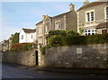
1
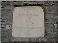
Modern miles
A milestone, looking rather modern, on Bitton's High Street. There does not appear to have been an older version here. See Image] for a wider view.
Image: © Neil Owen
Taken: 14 Dec 2016
0.06 miles
2
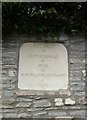
Old Milestone by the A431, High Street, Bitton
Carved stone plaque by the A431, in parish of BITTON (SOUTH GLOUCESTERSHIRE District), High Street, by junction with Golden Valley Lane, opposite Church Lane, inset into wall, on North side of road. Erected by the Bristol turnpike trust in the 20th century.
Inscription reads:-
BITTON
TO
BATH GUILDHALL
6
MILES
TO
BRISTOL CORNEXCHANGE (sic)
6
MILES
Milestone Society National ID: GL_BRBA06a.
Image: © M Faherty
Taken: 21 Jul 2011
0.06 miles
3
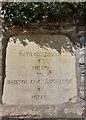
Old Milestone by the A431, High Street, Bitton
Carved stone plaque by the A431, in parish of BITTON (SOUTH GLOUCESTERSHIRE District), High Street, by junction with Golden Valley Lane, opposite Church Lane, inset into wall, on North side of road. Erected by the Bristol turnpike trust in the 20th century.
Inscription reads:-
BITTON
TO
BATH GUILDHALL
6
MILES
TO
BRISTOL CORNEXCHANGE (sic)
6
MILES
Milestone Society National ID: GL_BRBA06a.
Image: © Nick Gillett
Taken: 25 Aug 2023
0.06 miles
4
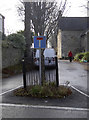
A tree in its own pen
A small tree, protected by railings, forms an island and a handy piece for road furniture in Church Lane. Closer inspection reveals a number of Monarch's Way stickers too.
Image: © Neil Owen
Taken: 14 Dec 2016
0.07 miles
5
A milestone in the wall
Bitton's High Street, featuring a milestone - see Image] for a closer look.
Image: © Neil Owen
Taken: 14 Dec 2016
0.07 miles
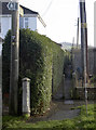
6
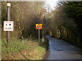
Plastic doesn't rust
A variety of signs on Golden Valley Lane.
Image: © Neil Owen
Taken: 14 Dec 2016
0.07 miles
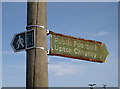
7
Off to Upton Cheyney
A slender footpath slips between houses in Bitton. It is part of the Monarch's Way Long Distance Path.
Image: © Neil Owen
Taken: 14 Dec 2016
0.07 miles
8
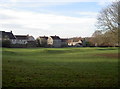
Bitton 'Camp'
Once mistakenly thought to be a Roman Camp, the earthworks are early Mediaeval at the oldest. Beyond is Baron Close, a modern road and housing. Before that, there was a small works there for most of the twentieth century but which has gone.
Image: © Neil Owen
Taken: 14 Dec 2016
0.08 miles
9
Golden Valley Lane
Beware of anything with legs!
Image: © Neil Owen
Taken: 14 Dec 2016
0.09 miles
10
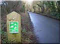
Quiet near Bitton
The lanes around the village are off the main Bath Road, but quickly become designated Quiet Lanes.
Image: © Neil Owen
Taken: 14 Dec 2016
0.09 miles