IMAGES TAKEN NEAR TO
Bath Road, BRISTOL, BS30 6HZ
Introduction
This page details the photographs taken nearby to Bath Road, BS30 6HZ by members of the Geograph project.
The Geograph project started in 2005 with the aim of publishing, organising and preserving representative images for every square kilometre of Great Britain, Ireland and the Isle of Man.

There are currently over 7.5m images from over14,400 individuals and you can help contribute to the project by visiting https://www.geograph.org.uk
Image Map (Loading...)


Getting Data...Please wait
Leaflet Map data © OpenStreetMap
Images are licensed for reuse under creativecommons.org/licenses/by-sa/2.0
Notes
- Clicking on the map will re-center to the selected point.
- The higher the marker number, the further away the image location is from the centre of the postcode.
Image Listing (113 Images Found)
Images are licensed for reuse under creativecommons.org/licenses/by-sa/2.0
Image
Details
Distance
1
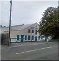
The Unity Tyre Co.
Warehouses are not usually attractive buildings, but the Unity Tyre Co. really looked after theirs, a landmark on the A431. After dealing in tyres of all sizes for 47 years, their business was taken over by RH Claydon Ltd. in November 2018. https://www.tyretradenews.co.uk/news/rh-claydon-ltd-announcement-re-unity-tyre-co-ltd One hopes that the new owners will keep the warehouse looking as good as it does now.
Image: © HelenK
Taken: 12 Sep 2019
0.01 miles
2
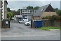
BT telephone exchange, Willsbridge
Open Reach vans are parked inside the BT premises on the south side of Bath Road.
Image: © Jaggery
Taken: 3 Sep 2011
0.03 miles
3
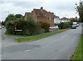
Cherry Gardens, Willsbridge
Cherry Gardens is a cul-de-sac (leading to Barry Close). Viewed from the edge of Bath Road (the A431).
Image: © Jaggery
Taken: 3 Sep 2011
0.04 miles
4
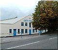
Unity Tyre depot, Bitton
This is the company's South West Depot, at 18/20 Bath Road, Bitton. Their website states that they supply a wide range of tyres, from mower to mover.
Image: © Jaggery
Taken: 3 Sep 2011
0.04 miles
5
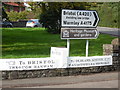
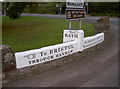
Signpost on wall near Bitton
This photo shows the signpost on the low wall at the junction of the A431 Bath Road and the A4175 Cherry Garden Road BS30 6JQ. The arrow to the left points to Bristol through Hanham along the A431 road, whilst the one to the right points to Oldland, Siston, Mangotsfield and Frenchay along the A4175 road. In the middle is the signpost to Bath along the A431 Bath Road. The black and white sign above refers to Bristol (A420) avoiding the 14ft 3in (4.3m) low bridge at Bitton Station nearby, and to Warmley (A4175). The brown sign below it gives the direction to the Heritage Museum and gardens in Tower Lane, Warmley, ST6672 refers.
Image: © David Hillas
Taken: 21 Sep 2017
0.05 miles
6
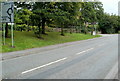
Left turn ahead for Bitton railway station
Viewed across the A431 Bath Road.
The brown sign on the right points left towards Bitton station on the Avon Valley Railway.
Image: © Jaggery
Taken: 3 Sep 2011
0.05 miles
7

2010 : A431 Bath Road heading south east
Between Willsbridge and Bitton.
The roundabout gives entry to the A4175 from Bridge Yate at the bottom of Cherry Garden Road.
Image: © Maurice Pullin
Taken: 15 Mar 2010
0.06 miles
8
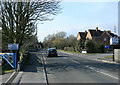
2010 : A431 Bath Road heading north west
Toward Willsbridge, Hanham and Bristol.
The small residential road to the right is Cherry Gardens.
The railway bridge in the distance carries the Avon Valley Railway which shares it with the Bristol and Bath Railway Path.
Image: © Maurice Pullin
Taken: 15 Mar 2010
0.06 miles
9
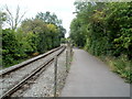
Bristol and Bath Railway Path SE of Bitton station
The footpath and cycleway here runs alongside the track of the heritage Avon Valley Railway.
A sign http://www.geograph.org.uk/photo/3282119 behind the camera shows that Bath is 7 miles ahead.
Image: © Jaggery
Taken: 3 Sep 2011
0.06 miles
10
This way, that way, the other way
A well-maintained wayside direction sign, giving a pointer to one of the three roads at this junction. Located on the A431/A4175 at Oldland, on what appears to have been a minor Roman road.
Image: © Neil Owen
Taken: 17 Oct 2011
0.07 miles