IMAGES TAKEN NEAR TO
Tayman Ridge, BRISTOL, BS30 6HY
Introduction
This page details the photographs taken nearby to Tayman Ridge, BS30 6HY by members of the Geograph project.
The Geograph project started in 2005 with the aim of publishing, organising and preserving representative images for every square kilometre of Great Britain, Ireland and the Isle of Man.

There are currently over 7.5m images from over14,400 individuals and you can help contribute to the project by visiting https://www.geograph.org.uk
Image Map (Loading...)


Getting Data...Please wait
Leaflet Map data © OpenStreetMap
Images are licensed for reuse under creativecommons.org/licenses/by-sa/2.0
Notes
- Clicking on the map will re-center to the selected point.
- The higher the marker number, the further away the image location is from the centre of the postcode.
Image Listing (49 Images Found)
Images are licensed for reuse under creativecommons.org/licenses/by-sa/2.0
Image
Details
Distance
1
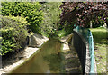
2009 : River Boyd looking upstream
From the bridge carrying the A431 at Bitton.
At one time the river carried raw effluent from the area into the River Avon just over half a mile to the south. Much cleaner now its condition then can hardly be imagined.
Image: © Maurice Pullin
Taken: 2 May 2009
0.04 miles
2
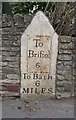
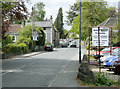
Old Milestone by the A431, Bath Road, Bitton parish
Metal plate attached to stone post by the A431, in parish of BITTON (SOUTH GLOUCESTERSHIRE District), Bath Road, opposite No. 116, junction with Tayman Ridge, West of river bridge, inset into wall, on North side of road. Erected by the Bristol turnpike trust in the 18th century.
Inscription reads:-
To
Briftol
6
To Bath
6
MILES
Grade II listed.
List Entry Number: 1116779 https://historicengland.org.uk/listing/the-list/list-entry/1116779
Milestone Society National ID: GL_BRBA06.
Image: © M Faherty
Taken: 8 Oct 2010
0.05 miles
3
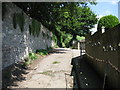
The south end of Clay Lane
With a wall on the left and houses on the right, Clay Lane heads up Bitton Hill
Image: © James Ayres
Taken: 10 Aug 2012
0.05 miles
4
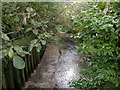
Bitton, River Boyd
Culverted, seen flowing downstream.
Image: © Mike Faherty
Taken: 8 Oct 2010
0.06 miles
5
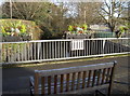
A view of the bridge
A handy seat for passers-by to use and admire the bridge railings. The planters provide some value.
Image: © Neil Owen
Taken: 14 Dec 2016
0.06 miles
6
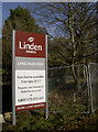
More land needed
Linden Homes have attained the former mill site in Bitton - quite a catch at over seven hectares (17.29 acres) - but clearly haven't finished buying land yet.
Image: © Neil Owen
Taken: 14 Dec 2016
0.06 miles
7
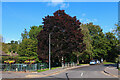
Somerville Way
Residential road in Bitton.
Image: © Wayland Smith
Taken: 10 Oct 2021
0.06 miles
8
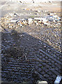
An industrial relic
Some hefty ironwork in the ground, possibly a weigh-bridge? Parsons were a foundry in Bradford that produced them. The site was lastly a car parts factory, using wood pulp for interior fittings; however that has now been cleared for a housing redevelopment.
Image: © Neil Owen
Taken: 14 Dec 2016
0.06 miles
9
2009 : A431 about to leave Bitton
Standing on the bridge over the River Boyd looking north west toward Willsbridge, Hanham and Bristol.
There is still some local industry.
Image: © Maurice Pullin
Taken: 2 May 2009
0.07 miles
10
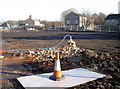
Cleared for new homes
This is the large former industrial site that was the fulcrum of Bitton's heritage for many years. This site beside the River Boyd was variously a brass mill, paper mill and car parts factory. However, the businesses finally closed in 2006 and the site left in limbo. Eventually, the permissions and fundings were sealed and the large area is to be redeveloped for 110 new 1-,2-,3- and 4-bedroomed houses.
Image: © Neil Owen
Taken: 14 Dec 2016
0.07 miles