IMAGES TAKEN NEAR TO
Church Farm Paddock, Church Road, BRISTOL, BS30 6HW
Introduction
This page details the photographs taken nearby to Church Farm Paddock, Church Road, BS30 6HW by members of the Geograph project.
The Geograph project started in 2005 with the aim of publishing, organising and preserving representative images for every square kilometre of Great Britain, Ireland and the Isle of Man.

There are currently over 7.5m images from over14,400 individuals and you can help contribute to the project by visiting https://www.geograph.org.uk
Image Map
Images are licensed for reuse under creativecommons.org/licenses/by-sa/2.0
Notes
- Clicking on the map will re-center to the selected point.
- The higher the marker number, the further away the image location is from the centre of the postcode.
Image Listing (58 Images Found)
Images are licensed for reuse under creativecommons.org/licenses/by-sa/2.0
Image
Details
Distance
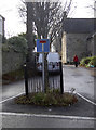
1
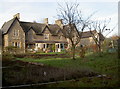
Frere Almshouses
Bitton was blessed by the construction of almshouses in 1859. The five homes were for 'aged married couples or surviving spouses, who shall be members of the Church of England and resident in Bitton for five years.' Above the lintel is the inscription "Frere Ayme Frere" - referring to brotherly love. The front lawns are part allotments.
Image: © Neil Owen
Taken: 14 Dec 2016
0.03 miles
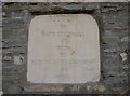
2
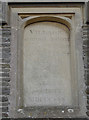
A school by voluntary subscription
St Mary's hall was originally a school for the local children. See Image] for a wider look.
The inscription reads:
'Village School Room built by voluntary contribution added to a grant from the National Society MDCCCXXX.'
Image: © Neil Owen
Taken: 14 Dec 2016
0.04 miles
3
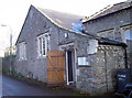
St Mary's Church Hall
Bitton's principal meeting hall, nowadays the village hall but originally a school house. See Image] for a stone tablet. Bitton had a record of poor education provision in the nineteenth century; the Lady Chapel of St Mary's church was used for teaching but was thought insufficient. Following public subscriptions and a grant from the National Society, a sum of £360 was used to build this school. It opened to boys (only!) of 5-12 in 1831, demanding an entrance fee of 6d, with reading 2d, reading and writing 3d, with reading writing and ciphering at 4d. The school later admitted girls, but a new school was built in the early 1900s; the parishioners again donated funds to buy the hall for the villagers' needs, which it fulfils to this day.
Image: © Neil Owen
Taken: 14 Dec 2016
0.04 miles
4
St Mary's through the Lych Gate
Bitton's prominent church and entrance.
Image: © Neil Owen
Taken: 14 Dec 2016
0.05 miles
5
A tree in its own pen
A small tree, protected by railings, forms an island and a handy piece for road furniture in Church Lane. Closer inspection reveals a number of Monarch's Way stickers too.
Image: © Neil Owen
Taken: 14 Dec 2016
0.08 miles
6
A milestone in the wall
Bitton's High Street, featuring a milestone - see Image] for a closer look.
Image: © Neil Owen
Taken: 14 Dec 2016
0.08 miles
7
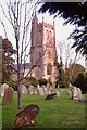
The 12c church of St Mary, Bitton.
It is commonly reported that a 'Grey Lady' (a ghost) is seen occasionally, passing from the vestry southwards and vanishing through the south wall to where there was once a 'Lepers' Window'.
Image: © Paul Wigmore
Taken: Unknown
0.09 miles
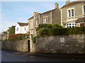
8
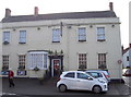
The White Hart in Bitton
Bitton only has the one pub in the village these days. It has had some ups and downs in the recent past but is still open to all visitors.
Image: © Neil Owen
Taken: 14 Dec 2016
0.09 miles
9
Modern miles
A milestone, looking rather modern, on Bitton's High Street. There does not appear to have been an older version here. See Image] for a wider view.
Image: © Neil Owen
Taken: 14 Dec 2016
0.09 miles
10
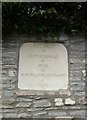
Old Milestone by the A431, High Street, Bitton
Carved stone plaque by the A431, in parish of BITTON (SOUTH GLOUCESTERSHIRE District), High Street, by junction with Golden Valley Lane, opposite Church Lane, inset into wall, on North side of road. Erected by the Bristol turnpike trust in the 20th century.
Inscription reads:-
BITTON
TO
BATH GUILDHALL
6
MILES
TO
BRISTOL CORNEXCHANGE (sic)
6
MILES
Milestone Society National ID: GL_BRBA06a.
Image: © M Faherty
Taken: 21 Jul 2011
0.09 miles