IMAGES TAKEN NEAR TO
Cunnington Close, BRISTOL, BS30 6ER
Introduction
This page details the photographs taken nearby to Cunnington Close, BS30 6ER by members of the Geograph project.
The Geograph project started in 2005 with the aim of publishing, organising and preserving representative images for every square kilometre of Great Britain, Ireland and the Isle of Man.

There are currently over 7.5m images from over14,400 individuals and you can help contribute to the project by visiting https://www.geograph.org.uk
Image Map (Loading...)


Getting Data...Please wait
Leaflet Map data © OpenStreetMap
Images are licensed for reuse under creativecommons.org/licenses/by-sa/2.0
Notes
- Clicking on the map will re-center to the selected point.
- The higher the marker number, the further away the image location is from the centre of the postcode.
Image Listing (91 Images Found)
Images are licensed for reuse under creativecommons.org/licenses/by-sa/2.0
Image
Details
Distance
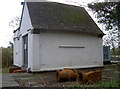
1

Cunnington Close
This short street of a few houses is Cunnington Close - named after A.J. Cunnington. He was a local beneficiary. A 1956 plaque on the wall from Warmley R.D.C. states he gave 'Brockham Hill House and Garden with the wish that Cottages should be erected and his Garden enjoyed by elderly people.'
Image: © Neil Owen
Taken: 28 Jan 2016
0.00 miles
2
Rusty old pipes
The small pumping station at Willsbridge (14064) seems to have found a couple of problems and left them out of the system.
Image: © Neil Owen
Taken: 28 Jan 2016
0.01 miles
3
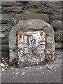
Too rusty to read
An old and rather neglected milestone still has some information to guide travellers. In better days you would have understood it is 5 miles to Bristol and 7 to Bath. Mind you, at least the iron plate remains - unlike many others.
Image: © Neil Owen
Taken: 28 Jan 2016
0.03 miles
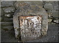
4

Bitton parish marker stone
A somewhat sombre-looking stone denotes the parish boundary. A pumping station is in the background.
Image: © Neil Owen
Taken: 28 Jan 2016
0.03 miles
5
Powerlines crossing the road near the "Queens Head"
Powerlines crossing the road at Willsbridge.
Image: © Ruth Riddle
Taken: 4 May 2012
0.03 miles
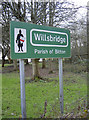
6
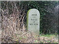
Modern Waymarker on the A431 Bath Road, Willsbridge
The waymarker marks the boundary of Bitton parish.
The inscription reads: 2000 : A.D. : Parish : of : BITTON
Milestone Society National ID: GL_BIT01
Image: © Jan Scrine
Taken: 19 Feb 2011
0.03 miles
7
Old Milestone by the A431, Bath Road, Willsbridge, Oldland Parish
Metal plate attached to stone post by the A431, in parish of OLDLAND (SOUTH GLOUCESTERSHIRE District), Bath Road, Willsbridge, next to entrance No.63, against wall, on North East side of road. Bristol incised iron plate, erected by the Bristol turnpike trust in the 18th century.
Inscription reads:- : To / Bristol / 5 :
Grade II Listed. List Entry Number: 1116198
Milestone Society National ID: GL_BRBA05.
Image: © M Faherty
Taken: 8 Oct 2010
0.04 miles
8
Welcome to Willsbridge
The village sign is a bit more intimidating than the locals.
Image: © Neil Owen
Taken: 28 Jan 2016
0.04 miles
9
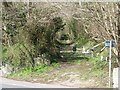
The route of the Dramway, north of Bath Road
Once a horse-drawn railway taking coal down to a wharf on the River Avon. Now a private track.
Image: © Christine Johnstone
Taken: 27 Mar 2016
0.04 miles
10
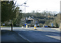
2010 : A431 at the junction with the A4175
Bath Road and Willsbridge Hill to the right, the A4175 leaves for Keynsham to the left, an ungainly pylon spoils the view. Bath Road, incidentally, comes from Bristol and Hanham, it goes to Bath along the road behind the camera.
The dramway which once carried coal by horsedrawn waggons crossed here after coming from mines at Coalpit Heath on their way to a wharf on the River Avon between Keynsham and Hanham Mills.
Image: © Maurice Pullin
Taken: 15 Mar 2010
0.04 miles