IMAGES TAKEN NEAR TO
Ludlow Close, BRISTOL, BS30 6EB
Introduction
This page details the photographs taken nearby to Ludlow Close, BS30 6EB by members of the Geograph project.
The Geograph project started in 2005 with the aim of publishing, organising and preserving representative images for every square kilometre of Great Britain, Ireland and the Isle of Man.

There are currently over 7.5m images from over14,400 individuals and you can help contribute to the project by visiting https://www.geograph.org.uk
Image Map
Images are licensed for reuse under creativecommons.org/licenses/by-sa/2.0
Notes
- Clicking on the map will re-center to the selected point.
- The higher the marker number, the further away the image location is from the centre of the postcode.
Image Listing (114 Images Found)
Images are licensed for reuse under creativecommons.org/licenses/by-sa/2.0
Image
Details
Distance
1
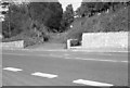
Tramroad crossing of Willsbridge Hill (1966)
In the distance is the southern portal of Willsbridge Tunnel, the longest on the A&GR at 150yds. There is quite a steep gradient from there down to the road, now the A431. This follows the course of the Via Julia, the Roman Road that linked Bath with South Wales & Carmarthen, via a ferry crossing of the River Severn at Aust. (For my 2019 photo see Image).
Image: © Martin Tester
Taken: Unknown
0.04 miles
2
Tramroad crossing of Willsbridge Hill
In the distance is the southern portal of Willsbridge Tunnel, the longest on the A&GR at 150yds. There is quite a steep gradient from there down to the road, now the A431. This follows the course of the Via Julia, the Roman Road that linked Bath with South Wales & Carmarthen, via a ferry crossing of the River Severn at Aust. (For my 1966 photo see Image).
Image: © Martin Tester
Taken: 27 Sep 2019
0.04 miles
3
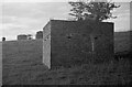
Ventilation Shafts, Willsbridge Hill tramroad tunnel (1966)
The 156 yards long Willsbridge Hill Tunnel of the Avon & Gloucestershire Railway had 2 ventilation shafts, 200 feet apart. Unusually the southern one was square and the northern one round! This difference can be made out here - I didn't take a photo of the round one, perhaps the approaching cow discouraged me! The missing bricks are a bit odd. During WWII the tunnel was used as an air-raid shelter and these 2 shafts were covered to prevent light escaping; I can only surmise that the bricks were knocked out to improve ventilation. After the war the tunnel was used to grow mushrooms. For a photo of the southern approach to the tunnel see: Image
Image: © Martin Tester
Taken: 1 May 1966
0.04 miles
4
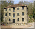
Willsbridge Mill
Willsbridge Mill is the Avon Wildlife’s Trust's main visitor centre, set in a 22 acre nature reserve which has interesting walks. In the early 1800’s it was an iron mill, and later became a flour mill.
More information http://www.radisol.co.uk/districtweb/main-site/history-willsbridge-mill.htm
Image: © Rick Crowley
Taken: 11 Mar 2010
0.09 miles
5
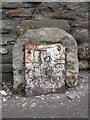
Old Milestone by the A431, Bath Road, Willsbridge, Oldland Parish
Metal plate attached to stone post by the A431, in parish of OLDLAND (SOUTH GLOUCESTERSHIRE District), Bath Road, Willsbridge, next to entrance No.63, against wall, on North East side of road. Bristol incised iron plate, erected by the Bristol turnpike trust in the 18th century.
Inscription reads:- : To / Bristol / 5 :
Grade II Listed. List Entry Number: 1116198
Milestone Society National ID: GL_BRBA05.
Image: © M Faherty
Taken: 8 Oct 2010
0.10 miles
6
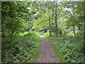
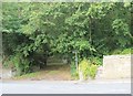
Willsbridge, footpath
From Bath Road through Willsbridge Valley Local Nature Reserve.
Image: © Mike Faherty
Taken: 8 Oct 2010
0.10 miles
7
Willsbridge Mill wildlife area
Once a thriving industrial place, featuring a slaughterhouse, tannery, milling, quarrying and coal-mining, it has lost almost all of its original employers. Having been taken into the care of the Avon Wildlife Trust it has been developed as a peaceful wooded valley and is home to many species of plants, insects and animals - including several rare examples. It is part of the Forest of Avon and visitors can see the sculpture trail and look around the restored mill.
Image: © Neil Owen
Taken: 28 Jan 2016
0.11 miles
8
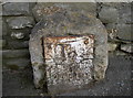
Too rusty to read
An old and rather neglected milestone still has some information to guide travellers. In better days you would have understood it is 5 miles to Bristol and 7 to Bath. Mind you, at least the iron plate remains - unlike many others.
Image: © Neil Owen
Taken: 28 Jan 2016
0.11 miles
9
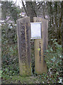
Wilsbridge Valley marker
The valley was once home to some heavy industries before becoming a nature reserve. This substantial marker lends weight to the impression given to visitors.
Image: © Neil Owen
Taken: 28 Jan 2016
0.11 miles
10
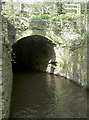
A short tunnel
The Siston Brook makes a momentary dive under a tunnel, close to the old mill.
Image: © Neil Owen
Taken: 27 Mar 2017
0.11 miles