IMAGES TAKEN NEAR TO
Harrington Close, BRISTOL, BS30 6AT
Introduction
This page details the photographs taken nearby to Harrington Close, BS30 6AT by members of the Geograph project.
The Geograph project started in 2005 with the aim of publishing, organising and preserving representative images for every square kilometre of Great Britain, Ireland and the Isle of Man.

There are currently over 7.5m images from over14,400 individuals and you can help contribute to the project by visiting https://www.geograph.org.uk
Image Map (Loading...)


Getting Data...Please wait
Leaflet Map data © OpenStreetMap
Images are licensed for reuse under creativecommons.org/licenses/by-sa/2.0
Notes
- Clicking on the map will re-center to the selected point.
- The higher the marker number, the further away the image location is from the centre of the postcode.
Image Listing (61 Images Found)
Images are licensed for reuse under creativecommons.org/licenses/by-sa/2.0
Image
Details
Distance
1
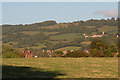
View from King's Square, Bitton.
The village of North Stoke is seen halfway up the hill.
Image: © Paul Wigmore
Taken: Unknown
0.05 miles
2
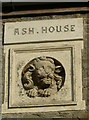
Ash House
The lion looks rather startled and fearful that his house might be due to receive a visit from the bulldozers. See Image] for a wider look at the surviving houses.
Image: © Neil Owen
Taken: 14 Dec 2016
0.05 miles
3
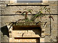
Heather House with additional species
The porch of the old buildings next to the old mill site have been boarded up. The name is somewhat compromised by what might be a buddleia that has grown in the masonry. See Image] for a wider view.
Image: © Neil Owen
Taken: 14 Dec 2016
0.05 miles
4
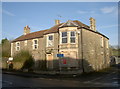
Closed, but saved for now
Two old houses fronting onto the Bath Road in Bitton look to be part of the old mills and factory that are now being bulldozed. See Image] and Image] for a closer view.
Image: © Neil Owen
Taken: 14 Dec 2016
0.05 miles
5
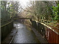
Iron sided
The River Boyd is a relatively small watercourse, rising in the hills a few miles to the north and heading down to the Avon. However, it does have a history of causing flooding in the area. The original bridge was considered insecure and this new version was built in 1972. The river banks were also sculpted extensively with iron sheeting, along with a 'ski-jump' weir.
Image: © Neil Owen
Taken: 14 Dec 2016
0.06 miles
6
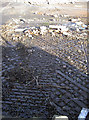
An industrial relic
Some hefty ironwork in the ground, possibly a weigh-bridge? Parsons were a foundry in Bradford that produced them. The site was lastly a car parts factory, using wood pulp for interior fittings; however that has now been cleared for a housing redevelopment.
Image: © Neil Owen
Taken: 14 Dec 2016
0.06 miles
7
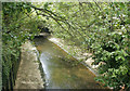
2009 : River Boyd from the A431 at Bitton
The River Boyd rises near the M4 to the west of Tormarton and flows west then south to Wick then Bitton and joins the Avon a little over half a mile from here.
Image: © Maurice Pullin
Taken: 2 May 2009
0.06 miles
8
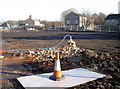
Cleared for new homes
This is the large former industrial site that was the fulcrum of Bitton's heritage for many years. This site beside the River Boyd was variously a brass mill, paper mill and car parts factory. However, the businesses finally closed in 2006 and the site left in limbo. Eventually, the permissions and fundings were sealed and the large area is to be redeveloped for 110 new 1-,2-,3- and 4-bedroomed houses.
Image: © Neil Owen
Taken: 14 Dec 2016
0.06 miles
9
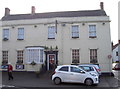
The White Hart in Bitton
Bitton only has the one pub in the village these days. It has had some ups and downs in the recent past but is still open to all visitors.
Image: © Neil Owen
Taken: 14 Dec 2016
0.07 miles
10
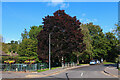
Somerville Way
Residential road in Bitton.
Image: © Wayland Smith
Taken: 10 Oct 2021
0.07 miles