IMAGES TAKEN NEAR TO
Hanging Hill, BRISTOL, BS30 5RW
Introduction
This page details the photographs taken nearby to Hanging Hill, BS30 5RW by members of the Geograph project.
The Geograph project started in 2005 with the aim of publishing, organising and preserving representative images for every square kilometre of Great Britain, Ireland and the Isle of Man.

There are currently over 7.5m images from over14,400 individuals and you can help contribute to the project by visiting https://www.geograph.org.uk
Image Map (Loading...)


Getting Data...Please wait
Leaflet Map data © OpenStreetMap
Images are licensed for reuse under creativecommons.org/licenses/by-sa/2.0
Notes
- Clicking on the map will re-center to the selected point.
- The higher the marker number, the further away the image location is from the centre of the postcode.
Image Listing (12 Images Found)
Images are licensed for reuse under creativecommons.org/licenses/by-sa/2.0
Image
Details
Distance
1
Beach Farm
The farmhouse occupies the site and possibly incorporates part of the farm burnt during the Battle of Lansdown in 1642. Current property is Grade II listed, being late 17th C or early 18th C. English Heritage Building ID: 28489.
See: http://www.britishlistedbuildings.co.uk/en-28489-beach-farmhouse-bitton
Image: © Stuart Logan
Taken: 22 Sep 2011
0.01 miles
2
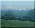
2010 : North west from Marshfield Lane
Near the junction with Bath Road.
From this position the sun was still below Lansdown (behind the camera) but was illuminating Wick, seen through the morning mist.
Frosty pastures, the stock is well protected.
Image: © Maurice Pullin
Taken: 3 Jan 2010
0.16 miles
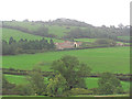
3
2010 : North near Beach Farm
View from Marshfield Lane.
Looking over a "resting" pasture to Copperfield Farm to the left.
Further over, to the right, the industrial buildings in the sun are at Wick Quarry.
To the left, level with the quarry, is part of the village of Wick.
Image: © Maurice Pullin
Taken: 3 Jan 2010
0.16 miles
4
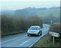
2010 : Unclassified road between Wick and Bath
At the junction with Marshfield Lane.
Leaves the A420 at Wick, crosses Lansdown Hill then descends into Bath. A road with some fine views on a clear day.
Seen here climbing the hill to Lansdown.
Image: © Maurice Pullin
Taken: 3 Jan 2010
0.19 miles
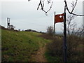
5
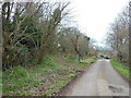
The Cotswold Way towards Hanging Hill
The Cotswold Way, day five 11:49am
Image: © Ian S
Taken: 21 Apr 2013
0.24 miles
6
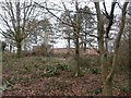
Avon Fire and Rescue Service Command Development Centre
The 'Command Development Centre' of Avon Fire & Rescue Service is tucked away among these trees. It is 'a high-tech centre for command training and incident simulation. The centre's main functions are incident command training, assessment, and personal development. The centre is also used as a meeting & conference centre. Learning and development is carried out ... using a full range of command simulation tools.' https://www.avonfire.gov.uk/our-services/southwest-command-development-centre
Image: © HelenK
Taken: 1 Jan 2019
0.24 miles
7
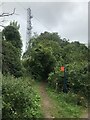
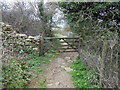
The Cotswold Way at Beech Wood
The Cotswold Way, day five 11:47am
Image: © Ian S
Taken: 21 Apr 2013
0.24 miles
8
The Cotswold Way towards Hanging Hill
The Cotswold Way, day five 11:49am
Image: © Ian S
Taken: 21 Apr 2013
0.24 miles
9
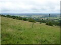
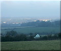
View from Hanging Hill
View to the west from the Cotswold Way from Hanging Hill. The city of Bristol is in the distance.
Image: © Philip Halling
Taken: 12 Jul 2021
0.24 miles