IMAGES TAKEN NEAR TO
London Road, BRISTOL, BS30 5RU
Introduction
This page details the photographs taken nearby to London Road, BS30 5RU by members of the Geograph project.
The Geograph project started in 2005 with the aim of publishing, organising and preserving representative images for every square kilometre of Great Britain, Ireland and the Isle of Man.

There are currently over 7.5m images from over14,400 individuals and you can help contribute to the project by visiting https://www.geograph.org.uk
Image Map
Images are licensed for reuse under creativecommons.org/licenses/by-sa/2.0
Notes
- Clicking on the map will re-center to the selected point.
- The higher the marker number, the further away the image location is from the centre of the postcode.
Image Listing (6 Images Found)
Images are licensed for reuse under creativecommons.org/licenses/by-sa/2.0
Image
Details
Distance
1
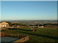
Toghill House Farm
A view from the window of one of the bed and breakfast bedrooms at Toghill House Farm, with the two white towers of the Severn Bridge just visible on the horizon near the left.
Image: © Stephen Dawson
Taken: 5 Oct 2003
0.11 miles
5
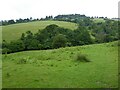
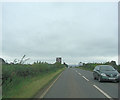
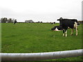
Farmland and Tog Hill
Farmland and Tog Hill viewed from the Cotswold Way and Greenway Lane.
Image: © Philip Halling
Taken: 12 Jul 2021
0.24 miles
6
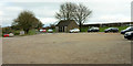
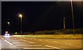
Car park, Tog Hill
A car park, picnic area and public conveniences near the junction of the A420 with Gorse Lane / Freezinghill Lane.
Image: © Derek Harper
Taken: 7 Dec 2019
0.24 miles