IMAGES TAKEN NEAR TO
Mendip View, BRISTOL, BS30 5PX
Introduction
This page details the photographs taken nearby to Mendip View, BS30 5PX by members of the Geograph project.
The Geograph project started in 2005 with the aim of publishing, organising and preserving representative images for every square kilometre of Great Britain, Ireland and the Isle of Man.

There are currently over 7.5m images from over14,400 individuals and you can help contribute to the project by visiting https://www.geograph.org.uk
Image Map (Loading...)


Getting Data...Please wait
Leaflet Map data © OpenStreetMap
Images are licensed for reuse under creativecommons.org/licenses/by-sa/2.0
Notes
- Clicking on the map will re-center to the selected point.
- The higher the marker number, the further away the image location is from the centre of the postcode.
Image Listing (18 Images Found)
Images are licensed for reuse under creativecommons.org/licenses/by-sa/2.0
Image
Details
Distance
1
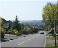
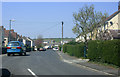
2010 : Looking down Naishcombe Hill, Wick
A recently developed residential area.
This minor road leaves the A420 near Boyd Bridge and heads north through Abson to Pucklechurch.
Image: © Maurice Pullin
Taken: 23 Apr 2010
0.07 miles
2
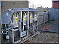
Festive fun at an electricity substation
Someone obviously had too many Christmas stickers - and probably too much Christmas spirit! Humbug!
Image: © Neil Owen
Taken: 2 Feb 2018
0.10 miles
3
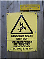
Little Riding electricity sub-station
On Naishcombe Hill since the 1950s. See Image for a look at an addition to the signage.
Image: © Neil Owen
Taken: 2 Feb 2018
0.10 miles
4
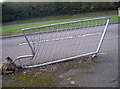
Shifted up the road
Someone had a bad moment - bad enough to uproot the foundations.
Image: © Neil Owen
Taken: 2 Feb 2018
0.11 miles
5
2010 : Parker's Avenue, Wick
A fairly recent housing development.
Image: © Maurice Pullin
Taken: 23 Apr 2010
0.12 miles
6
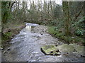
Some remains in the River Boyd
A section of concrete and rubble in the Boyd perhaps marks an old sluice.
Image: © Neil Owen
Taken: 2 Feb 2018
0.18 miles
7
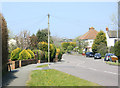
2010 : Naishcombe Hill, Wick looking north
Near the end of Parker's Avenue on the road to Abson and Pucklechurch.
Image: © Maurice Pullin
Taken: 23 Apr 2010
0.18 miles
8
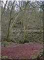
A rich red
The soil around the Boyd in Golden Valley is actually more red than gold. However, the red is indicative of the deposits of ochre that abounded here. Indeed, there was an ochre and oxide works just along the way from 1892-1970. The seam was largely worked out and so the works closed; given a little time and effort, the area has become a Local Nature Reserve.
Image: © Neil Owen
Taken: 2 Feb 2018
0.18 miles
9
House on London Road, Wick
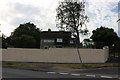
The nice hedge has just been replaced by this military style wall.
Image: © David Howard
Taken: 1 Jun 2019
0.19 miles
10
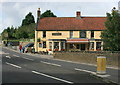
2008 : The Carpenter's Arms, Wick
The River Boyd flows unseen under the A420 here, joining the Avon near Bitton.
Look here http://www.britishpubguide.com/cgi-bin/pub.cgi?results:Gloucestershire:917 for more about the Carpenter's Arms.
Image: © Maurice Pullin
Taken: 11 Sep 2008
0.19 miles