IMAGES TAKEN NEAR TO
Siston Hill, BRISTOL, BS30 5LT
Introduction
This page details the photographs taken nearby to Siston Hill, BS30 5LT by members of the Geograph project.
The Geograph project started in 2005 with the aim of publishing, organising and preserving representative images for every square kilometre of Great Britain, Ireland and the Isle of Man.

There are currently over 7.5m images from over14,400 individuals and you can help contribute to the project by visiting https://www.geograph.org.uk
Image Map
Images are licensed for reuse under creativecommons.org/licenses/by-sa/2.0
Notes
- Clicking on the map will re-center to the selected point.
- The higher the marker number, the further away the image location is from the centre of the postcode.
Image Listing (15 Images Found)
Images are licensed for reuse under creativecommons.org/licenses/by-sa/2.0
Image
Details
Distance
1
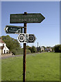
Footpath signpost on Goose Green
A mixture of vintages when to comes to signs.
Image: © Neil Owen
Taken: 26 Sep 2018
0.02 miles
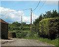
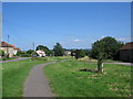
2
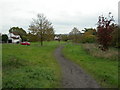
Community Forest Path at Goose Green
Following South Gloucestershire footpath PSN 49/50 to turn left and right across the green.
Image: © Derek Harper
Taken: 26 Dec 2024
0.02 miles
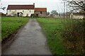
3
Community Forest Path, Goose Green
From the same spot as Image], with the Path leaving this side road via the gate visible in the background.
Image: © Derek Harper
Taken: 29 May 2015
0.03 miles
4
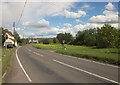
Goose Green
From the Community Forest Path as it crosses the road from Siston Hill to Webb's Heath, with the wide verge that forms part of Siston Common.
Image: © Derek Harper
Taken: 29 May 2015
0.03 miles
5
Siston, footpath
Across Siston Common.
Image: © Mike Faherty
Taken: 29 Oct 2010
0.04 miles
6
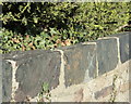
2009: Copper slag as a building material on Goose Green
During this period around 300 tons of brass was being produced each year from furnaces in six Brasshouses. Each of these Brasshouses would have had about six furnaces. The Brasshouses were topped with large cones similar to those used in the glass industry."
The above was copied from: http://www.csm.uwe.ac.uk/~rstephen/livingeaston/local_history/brass2.html
Image: © Maurice Pullin
Taken: 12 Oct 2009
0.05 miles
7
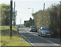
2009 : Minor road over Goose Green
Passing Cherryorchard Farm.
The clock tower of Cossham Hospital Image is on the horizon.
Image: © Maurice Pullin
Taken: 12 Oct 2009
0.08 miles
8
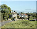
2009 : Cottages on Goose Green
Part of Siston Common. (sometimes spelled "Syston")
An interesting link here, cyclists, Dr.Who and everybody else beware http://www.machinehead-software.co.uk/bristol/cycle_track/siston_common.html
Image: © Maurice Pullin
Taken: 12 Oct 2009
0.09 miles
9
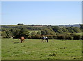
Enjoying a little light lunch
A couple of horses in a paddock enjoy some balmy late September sun whilst the grass is lush.
Image: © Neil Owen
Taken: 26 Sep 2018
0.11 miles
10
Goose Green
A view looking east over Goose Green towards the distant ridge of Tog Hill on the lower Cotswolds.
Image: © Phil Williams
Taken: 13 Jul 2006
0.11 miles