IMAGES TAKEN NEAR TO
Southway Drive, BRISTOL, BS30 5LF
Introduction
This page details the photographs taken nearby to Southway Drive, BS30 5LF by members of the Geograph project.
The Geograph project started in 2005 with the aim of publishing, organising and preserving representative images for every square kilometre of Great Britain, Ireland and the Isle of Man.

There are currently over 7.5m images from over14,400 individuals and you can help contribute to the project by visiting https://www.geograph.org.uk
Image Map (Loading...)


Getting Data...Please wait
Leaflet Map data © OpenStreetMap
Images are licensed for reuse under creativecommons.org/licenses/by-sa/2.0
Notes
- Clicking on the map will re-center to the selected point.
- The higher the marker number, the further away the image location is from the centre of the postcode.
Image Listing (18 Images Found)
Images are licensed for reuse under creativecommons.org/licenses/by-sa/2.0
Image
Details
Distance
1
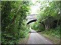
Poplar Road bridge
Over the Bristol and Bath cycle path and former railway
Image: © David Smith
Taken: 10 Jun 2017
0.06 miles
2
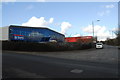
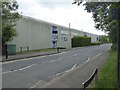
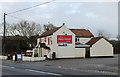
Commercial premises, North Common
The east Bristol 'rurban fringe' is a mosaic of large housing developments interspersed with small areas of commercial properties - plus the usual pubs, clubs and churches of course.
Image: © Gordon James
Taken: 20 Feb 2010
0.09 miles
3
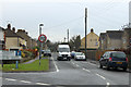
2011 : Poplar Road, North Common
One of the original roads passing through the area prior to its inevitable urbanisation.
Image: © Maurice Pullin
Taken: 17 Jan 2011
0.10 miles
4
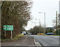
2011 : A4175 heading south through North Common
Wikipedia http://en.wikipedia.org/wiki/North_Common,_South_Gloucestershire tells us "North Common is a village just outside of Warmley, Bristol, in South Gloucestershire, England. Historically this was a rural hamlet surrounded by farmland. In recent years the area has seen several major housing developments."
Oldland Common follows.
Image: © Maurice Pullin
Taken: 17 Jan 2011
0.12 miles
5
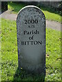
2011 : Millennium stone, Parish of Bitton
On the A4175 Bath Road at North Common, opposite the Hollybush Inn.
Image: © Maurice Pullin
Taken: 17 Jan 2011
0.13 miles
6
Gym building, Southway Drive
This industrial unit houses a gym
Image: © David Smith
Taken: 10 Jun 2017
0.13 miles
7
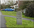
Not so old Boundary Marker on the A4175 Bath Road in Bitton
Commemorative Marker on the southwest side of the junction of the A4175 Bath Road and Poplar Road. Bitton parish. See also http://www.geograph.org.uk/photo/2243454.
Milestone Society National ID: GL_BITT05cm
Image: © Roadside Relics
Taken: 16 Sep 2020
0.14 miles
8
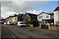
Poplar Rd, North Common
Clearly 'non-estate', Poplar Rd has a mix of properties ranging from old cottages to modern houses.
Image: © Gordon James
Taken: 20 Feb 2010
0.14 miles
9
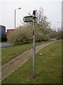
Dramway signpost
Once one of the last horse-drawn railways laid down in the country, this track is now a pleasant footpath that follows the old coal routes from Coalpit Heath down to the River Avon, some 9 miles south.
Image: © Neil Owen
Taken: 26 Mar 2011
0.14 miles
10
2011 : The Hollybush Inn, Bath Road, North Common
The A4175 passes the door.
Image: © Maurice Pullin
Taken: 17 Jan 2011
0.18 miles