IMAGES TAKEN NEAR TO
Mina Road, BRISTOL, BS2 9XW
Introduction
This page details the photographs taken nearby to Mina Road, BS2 9XW by members of the Geograph project.
The Geograph project started in 2005 with the aim of publishing, organising and preserving representative images for every square kilometre of Great Britain, Ireland and the Isle of Man.

There are currently over 7.5m images from over14,400 individuals and you can help contribute to the project by visiting https://www.geograph.org.uk
Image Map
Images are licensed for reuse under creativecommons.org/licenses/by-sa/2.0
Notes
- Clicking on the map will re-center to the selected point.
- The higher the marker number, the further away the image location is from the centre of the postcode.
Image Listing (61 Images Found)
Images are licensed for reuse under creativecommons.org/licenses/by-sa/2.0
Image
Details
Distance
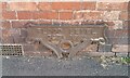
1
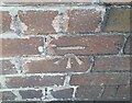
Ordnance Survey Cut Mark
This OS cut mark can be found on No68 Mina Road. It marks a point 10.769m above mean sea level.
Image: © Adrian Dust
Taken: 9 Oct 2021
0.05 miles
2
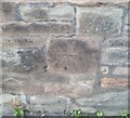
Ordnance Survey Cut Mark
This OS cut mark can be found on the school SW side of Stafford Road. It marks a point 12.171m above mean sea level.
Image: © Adrian Dust
Taken: 9 Oct 2021
0.07 miles
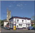
3
The Victoria, James Street
The Queen's head on the pub sign has been replaced with a poster of Jeremy Corbyn
Image: © Eirian Evans
Taken: 21 Sep 2017
0.08 miles
4
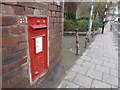
Bristol: postbox № BS2 8, Mina Road
An Edward VII-reign box, with its distinctive scroll-like cipher, set into a wall opposite the Sandbed Road turning. It is emptied finally at 5pm on weekdays and at 11:45am on Saturdays.
Image: © Chris Downer
Taken: 4 Apr 2012
0.11 miles
5
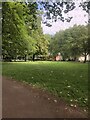
Mina Road Park
A municipal park which was laid out between 1884 and 1890. It is designed in a typical late-19th century style, with shrubberies, flower beds and a central grassed area.
Image: © Eirian Evans
Taken: 25 Jun 2023
0.11 miles
7
Ordnance Survey Cut Mark
This OS cut mark can be found on No52 Rosebery Avenue. It marks a point 14.57m above mean sea level.
Image: © Adrian Dust
Taken: 9 Oct 2021
0.12 miles
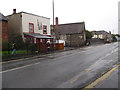
9
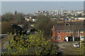
James Street, Bristol
From a railway bridge, with a terrace on Treefield Place, and a view to the city centre. Largely obscured in the left foreground is St Werburgh's Nursery School.
Image: © Derek Harper
Taken: 1 Apr 2019
0.13 miles
10

Ordnance Survey Cut Mark
This OS cut mark can be found on No57 Stafford Road. It marks a point 12.174m above mean sea level.
Image: © Adrian Dust
Taken: 9 Oct 2021
0.14 miles