IMAGES TAKEN NEAR TO
Gatton Road, BRISTOL, BS2 9TF
Introduction
This page details the photographs taken nearby to Gatton Road, BS2 9TF by members of the Geograph project.
The Geograph project started in 2005 with the aim of publishing, organising and preserving representative images for every square kilometre of Great Britain, Ireland and the Isle of Man.

There are currently over 7.5m images from over14,400 individuals and you can help contribute to the project by visiting https://www.geograph.org.uk
Image Map (Loading...)


Getting Data...Please wait
Leaflet Map data © OpenStreetMap
Images are licensed for reuse under creativecommons.org/licenses/by-sa/2.0
Notes
- Clicking on the map will re-center to the selected point.
- The higher the marker number, the further away the image location is from the centre of the postcode.
Image Listing (62 Images Found)
Images are licensed for reuse under creativecommons.org/licenses/by-sa/2.0
Image
Details
Distance
1
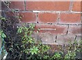
Ordnance Survey Cut Mark
This OS cut mark can be found on the SE side of Horley Road. It marks a point 12.415m above mean sea level.
Image: © Adrian Dust
Taken: 9 Oct 2021
0.03 miles
2
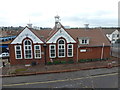
Bristol: St. Werburgh?s Community Centre
A community centre, perhaps a former school, viewed from the footbridge over the M32.
Image: © Chris Downer
Taken: 4 Apr 2012
0.04 miles
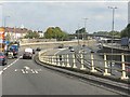
4
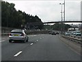
Bristol: the end of the M32
The M32 is the southward spur from the M4, linking with Bristol city centre. Here we see it approaching its final interchange, Junction 3, whereupon it becomes the A3042 into the heart of the city.
The on-slip from the roundabout coming towards us itself has a turn-off towards the Mina Road area.
Image: © Chris Downer
Taken: 4 Apr 2012
0.05 miles
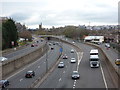
5
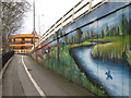
Street art near Mina Road
Towards St Werburghs, on the path from Easton that goes under the roundabout at Junction 3 of the M32.
Image: © George Evans
Taken: 13 Mar 2009
0.06 miles
6
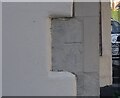
Ordnance Survey Cut Mark
This OS cut mark can be found on No52 Rosebery Avenue. It marks a point 14.57m above mean sea level.
Image: © Adrian Dust
Taken: 9 Oct 2021
0.06 miles
7
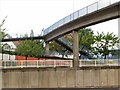
Head for Heights
This two-stage footbridge across the M32 at Baptist Mills, Bristol, is quite narrow and open to the elements. Not a crossing for those suffering from vertigo. The red brick building behind it is St. Werburgh's Community Hall.
Image: © Roger May
Taken: 19 Oct 2005
0.07 miles
8
M32 Motorway - footbridge near junction 3
Image: © J Whatley
Taken: 22 Sep 2010
0.08 miles
9
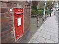
Bristol: postbox № BS2 8, Mina Road
An Edward VII-reign box, with its distinctive scroll-like cipher, set into a wall opposite the Sandbed Road turning. It is emptied finally at 5pm on weekdays and at 11:45am on Saturdays.
Image: © Chris Downer
Taken: 4 Apr 2012
0.08 miles
10
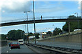
On the M32
Footbridge over the M32 at Easton.
Image: © Robert Ashby
Taken: 16 Aug 2014
0.08 miles