IMAGES TAKEN NEAR TO
Lemon Lane, BRISTOL, BS2 9HR
Introduction
This page details the photographs taken nearby to Lemon Lane, BS2 9HR by members of the Geograph project.
The Geograph project started in 2005 with the aim of publishing, organising and preserving representative images for every square kilometre of Great Britain, Ireland and the Isle of Man.

There are currently over 7.5m images from over14,400 individuals and you can help contribute to the project by visiting https://www.geograph.org.uk
Image Map
Images are licensed for reuse under creativecommons.org/licenses/by-sa/2.0
Notes
- Clicking on the map will re-center to the selected point.
- The higher the marker number, the further away the image location is from the centre of the postcode.
Image Listing (254 Images Found)
Images are licensed for reuse under creativecommons.org/licenses/by-sa/2.0
Image
Details
Distance
1
Newfoundland Circus
A variety of architectural styles on display here.
Image: © Thomas Nugent
Taken: 7 Sep 2010
0.02 miles
2
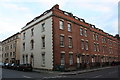
St Paul St Bristol
View south down St Paul Street looking away from St Pauls Square towards the city centre.
Image: © Nigel Mykura
Taken: 5 Aug 2009
0.03 miles
3
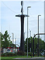
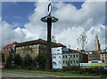
Newfoundland Circus
Is it art, is at a phone mast, is it a windmill? Information welcome.
Image: © Thomas Nugent
Taken: 7 Sep 2010
0.03 miles
4

Newfoundland Road Police station
A more modern building to complement the rest of the development in the area, standing as it does at the junction between the city centre and the M32.
Image: © Neil Owen
Taken: 23 Nov 2011
0.04 miles
5

Two Blues
The modern A&S Police station, complete with a couple of old-fashioned blue lights.
Image: © Neil Owen
Taken: 23 Nov 2011
0.04 miles
6
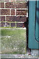
Benchmark on #1 St Paul Street (Wilson Street face)
Ordnance Survey cut mark benchmark described on the Bench Mark Database at http://www.bench-marks.org.uk/bm92767
Image: © Roger Templeman
Taken: 4 Feb 2018
0.04 miles
7
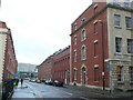
Buildings at the Wilson Street / St Paul Street junction
There is an OS benchmark Image on bricks at the corner, left hand face, of the nearest building
Image: © Roger Templeman
Taken: 4 Feb 2018
0.04 miles
8
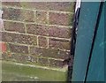
Ordnance Survey Cut Mark
This OS cut mark can be found on No1 St Paul's Street. It marks a point 15.091m above mean sea level.
Image: © Adrian Dust
Taken: 26 Jan 2020
0.04 miles
9
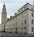
St Paul and 14-17 Portland Square, Bristol
The south-east corner of this plain but stately Georgian square, laid out, with the surrounding streets, by the architect Daniel Hague from c1787 (though not completed until c1823). Each house, in Bath stone, is of three storeys plus basement and attic, the end houses a storey higher, three bays wide, with a rusticated ground floor, and good pedimented doorcase. Grade I listed.
Hague was also responsible for the Gothick church, 1789-94, whose lofty tower has five stages in all. Grade I listed.
The church closed in 1988 and since 2005 has been occupied by Circomedia, "a drama school for circus performers, and a school for physical actors."
Image: © Stephen Richards
Taken: 20 May 2012
0.05 miles
10

The circus has come to town
Following the redevelopment of the main shopping area and its subsequent renaming as Cabot Circus, the approach roads were also altered.
Image: © Neil Owen
Taken: 23 Nov 2011
0.05 miles