IMAGES TAKEN NEAR TO
Little George Street, BRISTOL, BS2 9DQ
Introduction
This page details the photographs taken nearby to Little George Street, BS2 9DQ by members of the Geograph project.
The Geograph project started in 2005 with the aim of publishing, organising and preserving representative images for every square kilometre of Great Britain, Ireland and the Isle of Man.

There are currently over 7.5m images from over14,400 individuals and you can help contribute to the project by visiting https://www.geograph.org.uk
Image Map (Loading...)


Getting Data...Please wait
Leaflet Map data © OpenStreetMap
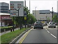
Images are licensed for reuse under creativecommons.org/licenses/by-sa/2.0
Notes
- Clicking on the map will re-center to the selected point.
- The higher the marker number, the further away the image location is from the centre of the postcode.
Image Listing (189 Images Found)
Images are licensed for reuse under creativecommons.org/licenses/by-sa/2.0
Image
Details
Distance
1
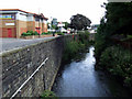
River Frome
At Houlton Street, with Wellington Road on the left.
Image: © Thomas Nugent
Taken: 7 Sep 2010
0.03 miles
2
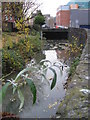
River Frome
The River Frome at Wellington Road, looking upstream towards St Pauls in the centre of Bristol, hardly ever seen by most travellers heading onto the M32 nearby.
Image: © Dr Duncan Pepper
Taken: 15 Nov 2008
0.06 miles
3
Houlton Street
Looking towards Wade Street. Wellington Road is on the left.
Image: © Thomas Nugent
Taken: 7 Sep 2010
0.06 miles
4
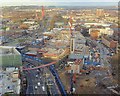
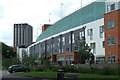
Regeneration in Bristol - the car park
The £500 million 'Cabot's Circus' regeneration scheme for Bristol city centre includes the construction of a 2,600 space car park. The car park (seen under construction in the photograph) lies between the M32 (centre-left of photo) and Bond Street (bottom of photo). The (not yet finished) footbridge which will link the car park to the House of Fraser and other shops can be seen crossing Bond Street.
Image: © Sharon Loxton
Taken: 2 Dec 2007
0.07 miles
5
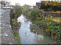
River Frome
Looking downstream at the point where the river disappears under Wade St Bridge and then under River St and Broadmead shopping centre to eventually emerge into the harbour at Broad Quay. The new Cabot Circus multi-storey carpark is visible on the right.
Image: © Dr Duncan Pepper
Taken: 15 Nov 2008
0.07 miles
6
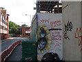
Election graffiti, Pennywell Road
There had been a general election about 6 weeks before this photo.
Image: © Stephen Craven
Taken: 24 Jun 2017
0.08 miles
7
River Street
The River Frome runs through here. Castlegate Tower is in the distance.
Image: © Thomas Nugent
Taken: 7 Sep 2010
0.10 miles
8
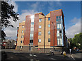
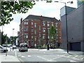
Saint Court, Lawfords Gate
A modern apartment block, presumably named with reference to St Nicholas church beyond it Image
Image: © Stephen Craven
Taken: 24 Jun 2017
0.10 miles
9
Car parking information sign, A4032, Bristol
Image: © J Whatley
Taken: 22 Sep 2010
0.10 miles
10
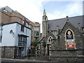
St Nicholas of Tolentino church
The church was founded in the earlier part of the 1800s, and has been extended on occasions since. Beside it used to be a school in the past, which is now replaced by some modern housing that crowds the old church rather.
Image: © Neil Owen
Taken: 5 May 2022
0.11 miles