IMAGES TAKEN NEAR TO
Ashley Trading Estate, Ashley Parade, BRISTOL, BS2 9BB
Introduction
This page details the photographs taken nearby to Ashley Trading Estate, Ashley Parade, BS2 9BB by members of the Geograph project.
The Geograph project started in 2005 with the aim of publishing, organising and preserving representative images for every square kilometre of Great Britain, Ireland and the Isle of Man.

There are currently over 7.5m images from over14,400 individuals and you can help contribute to the project by visiting https://www.geograph.org.uk
Image Map
Images are licensed for reuse under creativecommons.org/licenses/by-sa/2.0
Notes
- Clicking on the map will re-center to the selected point.
- The higher the marker number, the further away the image location is from the centre of the postcode.
Image Listing (75 Images Found)
Images are licensed for reuse under creativecommons.org/licenses/by-sa/2.0
Image
Details
Distance
1
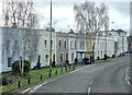
Elegant terrace
York Street / Sevier Street, Bristol
Image: © Anthony O'Neil
Taken: 3 Feb 2023
0.09 miles
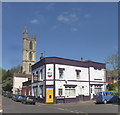
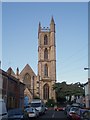
2
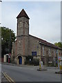
Ivy Pentecostal Church
At the bottom of Ashley Hill, Montpelier
Image: © Eirian Evans
Taken: 28 Oct 2016
0.09 miles
3
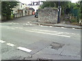
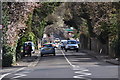
Ashley Hill road and footpath junctions
View across Ashley Hill from Briavels Grove towards track alongside railway (towards Montpelier station) and Fairfield Road. On the extreme right of the photo is the SE end of the railway bridge SW parapet.
Image: © Roger Templeman
Taken: 14 Aug 2010
0.12 miles
4
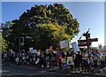
Environmental protest on Ashley Hill
Children from local Junior Schools protest on one Friday morning each month against environmental pollution
Image: © Eirian Evans
Taken: Unknown
0.12 miles
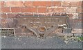
5
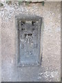
Ordnance Survey Flush Bracket (95)
This OS Flush Bracket can be found on Ashley Hill Railway Bridge. It marks a point 34.6680m above mean sea level.
Image: © Adrian Dust
Taken: 3 Mar 2016
0.12 miles
6
Bristol : Ashley Hill B4052
A road heading through the Bristol suburbs.
Image: © Lewis Clarke
Taken: 24 Mar 2015
0.13 miles
9
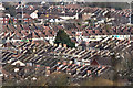
Bristol : City Scenery
Looking out across the rooftops and houses of the Bristol suburbs.
Image: © Lewis Clarke
Taken: 24 Mar 2015
0.13 miles
10
St Werburghs' Church, St Werburghs.
The 15th century St Werburghs' church originally stood in Corn Street in the centre of Bristol. It was moved to the area in 1879, and the whole district was subsequently named St Werburghs. It is now a climbing centre.
Image: © Sharon Loxton
Taken: 7 Jul 2006
0.13 miles