IMAGES TAKEN NEAR TO
Moor Road, BANWELL, BS29 6ET
Introduction
This page details the photographs taken nearby to Moor Road, BS29 6ET by members of the Geograph project.
The Geograph project started in 2005 with the aim of publishing, organising and preserving representative images for every square kilometre of Great Britain, Ireland and the Isle of Man.

There are currently over 7.5m images from over14,400 individuals and you can help contribute to the project by visiting https://www.geograph.org.uk
Image Map (Loading...)


Getting Data...Please wait
Leaflet Map data © OpenStreetMap
Images are licensed for reuse under creativecommons.org/licenses/by-sa/2.0
Notes
- Clicking on the map will re-center to the selected point.
- The higher the marker number, the further away the image location is from the centre of the postcode.
Image Listing (6 Images Found)
Images are licensed for reuse under creativecommons.org/licenses/by-sa/2.0
Image
Details
Distance
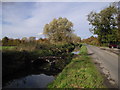
3
Small twin arched bridge over the River Banwell with flow gauge
Image: © Dr Duncan Pepper
Taken: 20 May 2011
0.23 miles
4
The River Banwell, south of Lower Gout Farm
Image: © John Lord
Taken: 30 Oct 2010
0.23 miles
5
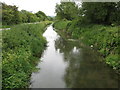
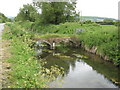
The River Banwell looking upstream beside Riverside Road
Image: © Dr Duncan Pepper
Taken: 20 May 2011
0.24 miles