IMAGES TAKEN NEAR TO
Dyer Street, BS29 6EN
Introduction
This page details the photographs taken nearby to Dyer Street, BS29 6EN by members of the Geograph project.
The Geograph project started in 2005 with the aim of publishing, organising and preserving representative images for every square kilometre of Great Britain, Ireland and the Isle of Man.

There are currently over 7.5m images from over14,400 individuals and you can help contribute to the project by visiting https://www.geograph.org.uk
Image Map
Images are licensed for reuse under creativecommons.org/licenses/by-sa/2.0
Notes
- Clicking on the map will re-center to the selected point.
- The higher the marker number, the further away the image location is from the centre of the postcode.
Image Listing (16 Images Found)
Images are licensed for reuse under creativecommons.org/licenses/by-sa/2.0
Image
Details
Distance
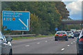
6
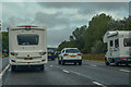
Banwell : M5 Motorway
The M5 Motorway between Junction 22 (Edithmead Interchange) and Junction 21 (St Georges Interchange).
Image: © Lewis Clarke
Taken: 22 Sep 2019
0.14 miles
7
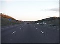
North Somerset : The M5 Motorway
The M5 Motorway heading south through North Somerset.
Image: © Lewis Clarke
Taken: 23 Mar 2014
0.15 miles
10
North Somerset : M5 Motorway
The M5 Motorway between Junction 22 (Edithmead Interchange) and Junction 21 (St Georges Interchange).
Image: © Lewis Clarke
Taken: 30 Sep 2018
0.20 miles