IMAGES TAKEN NEAR TO
City Road, BRISTOL, BS2 8UL
Introduction
This page details the photographs taken nearby to City Road, BS2 8UL by members of the Geograph project.
The Geograph project started in 2005 with the aim of publishing, organising and preserving representative images for every square kilometre of Great Britain, Ireland and the Isle of Man.

There are currently over 7.5m images from over14,400 individuals and you can help contribute to the project by visiting https://www.geograph.org.uk
Image Map
Images are licensed for reuse under creativecommons.org/licenses/by-sa/2.0
Notes
- Clicking on the map will re-center to the selected point.
- The higher the marker number, the further away the image location is from the centre of the postcode.
Image Listing (255 Images Found)
Images are licensed for reuse under creativecommons.org/licenses/by-sa/2.0
Image
Details
Distance
1
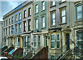
Large terrace houses
City Road, Bristol
Image: © Anthony O'Neil
Taken: 3 Feb 2023
0.01 miles
2
Electricity vent on Ashley Road
An underground substation has to bring fresh, cool air into the chambers.
Image: © Neil Owen
Taken: 11 Oct 2022
0.07 miles
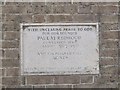
3
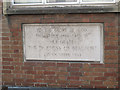
Foundation stone of St Paul's Settlement
The stone records that the building was opened by the Duchess of Beaufort on 23 October 1953. See Image for context.
Image: © Stephen Craven
Taken: 26 Jun 2017
0.07 miles
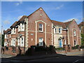
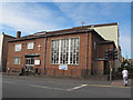
4
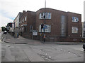
St Paul's Settlement, City Road, Bristol
The building, opened in 1953 Image, is home to various community organisations. On the corner of Brigstocke Road.
Image: © Stephen Craven
Taken: 26 Jun 2017
0.08 miles
5
Osbourne Court
A Bristol Churches Housing Association development, named after Olive Osbourne, B.E.M. She also opened the houses 9th July, 1993. It won a civic award at that time.
Image: © Neil Owen
Taken: 11 Oct 2022
0.08 miles
6
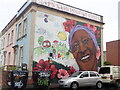
Dolores Campbell mural
At the corner of Campbell Street and Grosvenor Road, St Pauls. One of the "Seven Saints of St Pauls - Dolores Campbell was born in Jamaica. Equality, integration, and community were important to her. With fellow Saints of St Pauls, Dolores co-founded the St. Pauls’ Festival and the United Housing Association now known as United Communities.
Image: © Eirian Evans
Taken: 9 Jun 2022
0.08 miles
7
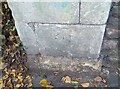
Ordnance Survey Cut Mark
This OS cut mark can be found on the gatepost of No65 Ashley Road. It marks a point 23.387m above mean sea level.
Image: © Adrian Dust
Taken: 9 Oct 2021
0.08 miles
8
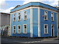
On the corner of Grosvenor Road
A blue house has been converted from a shop a few years ago. On the angle above where the door used to be is a short logo: 'May we never lose the wonder'.
Image: © Neil Owen
Taken: 13 Sep 2023
0.09 miles
9
Wesleyan Holiness Church, City Road, Bristol
A Methodist church on the corner of Brigstocke Road.
Image: © Stephen Craven
Taken: 26 Jun 2017
0.09 miles
10
Wesleyan Holiness Church - foundation stone
The stone records that the building was opened by the Duchess of Beaufort on 23 October 1953. See Image for context.
Image: © Stephen Craven
Taken: 26 Jun 2017
0.09 miles