IMAGES TAKEN NEAR TO
Gwyn Street, BRISTOL, BS2 8UG
Introduction
This page details the photographs taken nearby to Gwyn Street, BS2 8UG by members of the Geograph project.
The Geograph project started in 2005 with the aim of publishing, organising and preserving representative images for every square kilometre of Great Britain, Ireland and the Isle of Man.

There are currently over 7.5m images from over14,400 individuals and you can help contribute to the project by visiting https://www.geograph.org.uk
Image Map
Images are licensed for reuse under creativecommons.org/licenses/by-sa/2.0
Notes
- Clicking on the map will re-center to the selected point.
- The higher the marker number, the further away the image location is from the centre of the postcode.
Image Listing (308 Images Found)
Images are licensed for reuse under creativecommons.org/licenses/by-sa/2.0
Image
Details
Distance
1
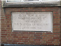
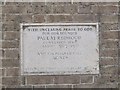
Foundation stone of St Paul's Settlement
The stone records that the building was opened by the Duchess of Beaufort on 23 October 1953. See Image for context.
Image: © Stephen Craven
Taken: 26 Jun 2017
0.05 miles
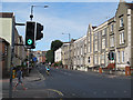
2
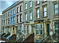
Large terrace houses
City Road, Bristol
Image: © Anthony O'Neil
Taken: 3 Feb 2023
0.05 miles
3
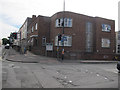
St Paul's Settlement, City Road, Bristol
The building, opened in 1953 Image, is home to various community organisations. On the corner of Brigstocke Road.
Image: © Stephen Craven
Taken: 26 Jun 2017
0.05 miles
4
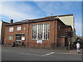
Wesleyan Holiness Church, City Road, Bristol
A Methodist church on the corner of Brigstocke Road.
Image: © Stephen Craven
Taken: 26 Jun 2017
0.06 miles
5
Wesleyan Holiness Church - foundation stone
The stone records that the building was opened by the Duchess of Beaufort on 23 October 1953. See Image for context.
Image: © Stephen Craven
Taken: 26 Jun 2017
0.06 miles
6
Junction of City Road and Brigstocke Road
Image: © Stephen Craven
Taken: 26 Jun 2017
0.07 miles
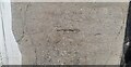
7

Benchmark on wall beside gate to #25 Ashley Road
Ordnance Survey cut mark benchmark described on the Bench Mark Database at http://www.bench-marks.org.uk/bm51177
Image: © Roger Templeman
Taken: 4 Feb 2018
0.07 miles
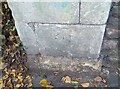
8
Ordnance Survey Cut Mark
This OS cut mark can be found on the wall of No25 Ashley Road. It marks a point 24.841m above mean sea level.
Image: © Adrian Dust
Taken: 9 Oct 2021
0.07 miles
9
Ordnance Survey Cut Mark
This OS cut mark can be found on the gatepost of No65 Ashley Road. It marks a point 23.387m above mean sea level.
Image: © Adrian Dust
Taken: 9 Oct 2021
0.07 miles
10
Electricity vent on Ashley Road
An underground substation has to bring fresh, cool air into the chambers.
Image: © Neil Owen
Taken: 11 Oct 2022
0.08 miles