IMAGES TAKEN NEAR TO
Hepburn Road, BRISTOL, BS2 8UD
Introduction
This page details the photographs taken nearby to Hepburn Road, BS2 8UD by members of the Geograph project.
The Geograph project started in 2005 with the aim of publishing, organising and preserving representative images for every square kilometre of Great Britain, Ireland and the Isle of Man.

There are currently over 7.5m images from over14,400 individuals and you can help contribute to the project by visiting https://www.geograph.org.uk
Image Map (Loading...)


Getting Data...Please wait
Leaflet Map data © OpenStreetMap
Images are licensed for reuse under creativecommons.org/licenses/by-sa/2.0
Notes
- Clicking on the map will re-center to the selected point.
- The higher the marker number, the further away the image location is from the centre of the postcode.
Image Listing (393 Images Found)
Images are licensed for reuse under creativecommons.org/licenses/by-sa/2.0
Image
Details
Distance
1
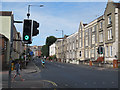
Junction of City Road and Brigstocke Road
Image: © Stephen Craven
Taken: 26 Jun 2017
0.03 miles
2
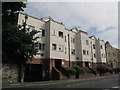
Dairy Croft, City Road
An unusual name for a housing block.
Image: © Stephen Craven
Taken: 26 Jun 2017
0.04 miles
3
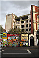
Derelict building in Bristol
This multi-storey building on the corner of Ashley Road and Cheltenham Road has been derelict for many years. One person fell to his death several years ago during a drug-fuelled escapade. Coloured hoardings now keep most people away from the site.
Image: © Bob Jones
Taken: 17 Jul 2009
0.04 miles
4
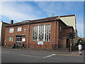
Wesleyan Holiness Church, City Road, Bristol
A Methodist church on the corner of Brigstocke Road.
Image: © Stephen Craven
Taken: 26 Jun 2017
0.04 miles
5
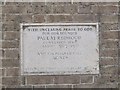
Wesleyan Holiness Church - foundation stone
The stone records that the building was opened by the Duchess of Beaufort on 23 October 1953. See Image for context.
Image: © Stephen Craven
Taken: 26 Jun 2017
0.04 miles
6
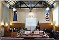
Bristol Citadel
The interior of Corps 150's church on Ashley Road, decked out in preparation for a wedding ceremony.
Image: © Martin Addison
Taken: 25 Jun 2011
0.05 miles
7
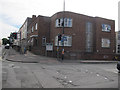
St Paul's Settlement, City Road, Bristol
The building, opened in 1953 Image, is home to various community organisations. On the corner of Brigstocke Road.
Image: © Stephen Craven
Taken: 26 Jun 2017
0.05 miles
8
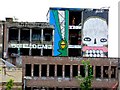
Graffiti Street Art Stokes Croft Bristol
View of graffiti on the top of some derelict office blocks at Cheltenham Rd and Ashley Rd, Stokes Croft. Viewed from Nine Tree Hill.
Image: © Nigel Mykura
Taken: 5 Aug 2009
0.06 miles
9
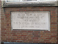
Foundation stone of St Paul's Settlement
The stone records that the building was opened by the Duchess of Beaufort on 23 October 1953. See Image for context.
Image: © Stephen Craven
Taken: 26 Jun 2017
0.06 miles
10
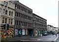
Street Art, Stokes Croft, Bristol
View along Cheltenham Rd looking south from close to the junction with Ashley Rd where there is extensive graffiti on the derelict office buildings.
Image: © Nigel Mykura
Taken: 5 Aug 2009
0.06 miles