IMAGES TAKEN NEAR TO
City Road, BRISTOL, BS2 8TX
Introduction
This page details the photographs taken nearby to City Road, BS2 8TX by members of the Geograph project.
The Geograph project started in 2005 with the aim of publishing, organising and preserving representative images for every square kilometre of Great Britain, Ireland and the Isle of Man.

There are currently over 7.5m images from over14,400 individuals and you can help contribute to the project by visiting https://www.geograph.org.uk
Image Map
Images are licensed for reuse under creativecommons.org/licenses/by-sa/2.0
Notes
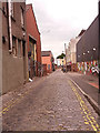
- Clicking on the map will re-center to the selected point.
- The higher the marker number, the further away the image location is from the centre of the postcode.
Image Listing (399 Images Found)
Images are licensed for reuse under creativecommons.org/licenses/by-sa/2.0
Image
Details
Distance
1
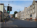
Junction of City Road and Brigstocke Road
Image: © Stephen Craven
Taken: 26 Jun 2017
0.02 miles
2
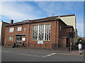
Wesleyan Holiness Church, City Road, Bristol
A Methodist church on the corner of Brigstocke Road.
Image: © Stephen Craven
Taken: 26 Jun 2017
0.02 miles
3
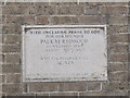
Wesleyan Holiness Church - foundation stone
The stone records that the building was opened by the Duchess of Beaufort on 23 October 1953. See Image for context.
Image: © Stephen Craven
Taken: 26 Jun 2017
0.02 miles
4
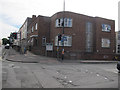
St Paul's Settlement, City Road, Bristol
The building, opened in 1953 Image, is home to various community organisations. On the corner of Brigstocke Road.
Image: © Stephen Craven
Taken: 26 Jun 2017
0.04 miles
5
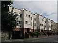
Dairy Croft, City Road
An unusual name for a housing block.
Image: © Stephen Craven
Taken: 26 Jun 2017
0.04 miles
6
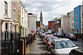
Brigstocke Road
A road which feels tightly packed, in the St Paul's district, named after the church visible here.
Image: © Bill Boaden
Taken: 15 Apr 2017
0.04 miles
7
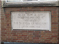
Foundation stone of St Paul's Settlement
The stone records that the building was opened by the Duchess of Beaufort on 23 October 1953. See Image for context.
Image: © Stephen Craven
Taken: 26 Jun 2017
0.05 miles
8
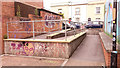
Ramp on Backfields Lane
The ramp gives step-free access to Brunswick Street.
Image: © Stephen Craven
Taken: 26 Jun 2017
0.05 miles
9
Backfields Lane, Bristol
It was a surprise to find this area of setted narrow streets with former (or maybe even current) factory buildings, so close to a vibrant city centre.
Image: © Stephen Craven
Taken: 26 Jun 2017
0.08 miles
10
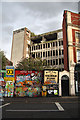
Derelict building in Bristol
This multi-storey building on the corner of Ashley Road and Cheltenham Road has been derelict for many years. One person fell to his death several years ago during a drug-fuelled escapade. Coloured hoardings now keep most people away from the site.
Image: © Bob Jones
Taken: 17 Jul 2009
0.08 miles