IMAGES TAKEN NEAR TO
Backfields Lane, BRISTOL, BS2 8QR
Introduction
This page details the photographs taken nearby to Backfields Lane, BS2 8QR by members of the Geograph project.
The Geograph project started in 2005 with the aim of publishing, organising and preserving representative images for every square kilometre of Great Britain, Ireland and the Isle of Man.

There are currently over 7.5m images from over14,400 individuals and you can help contribute to the project by visiting https://www.geograph.org.uk
Image Map
Images are licensed for reuse under creativecommons.org/licenses/by-sa/2.0
Notes
- Clicking on the map will re-center to the selected point.
- The higher the marker number, the further away the image location is from the centre of the postcode.
Image Listing (527 Images Found)
Images are licensed for reuse under creativecommons.org/licenses/by-sa/2.0
Image
Details
Distance
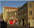
1
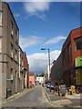
Backfields Lane, Bristol
A street off Upper York Street (foreground). At the far end is Brunswick Street, but you can't get through by car. On the corner are chairs for sale outside a shop run by Emmaus Bristol, a charity for the homeless.
Image: © Derek Harper
Taken: 29 Jul 2015
0.02 miles
2
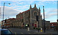
City Road Baptist Church, Bristol
The church is situated on City Road in the Stokes Croft & St Paul's neighbourhood of Bristol, just off the main A38 Gloucester Road. It was built in 1861 by Gloucester architects Medland and Maberly and is a Grade II listed building.
Image: © Eirian Evans
Taken: 31 Jul 2010
0.03 miles
3
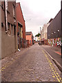
Backfields Lane, Bristol
It was a surprise to find this area of setted narrow streets with former (or maybe even current) factory buildings, so close to a vibrant city centre.
Image: © Stephen Craven
Taken: 26 Jun 2017
0.03 miles
4
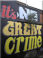
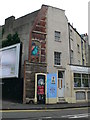
No great crime at all
Another formerly blank wall has been given the treatment. It's not on a particularly busy or prominent street, but it still gets a new look.
Image: © Neil Owen
Taken: 23 Nov 2011
0.03 miles
5

Faces along City Road
Plenty of high art.
Image: © Neil Owen
Taken: 11 Oct 2022
0.03 miles
6
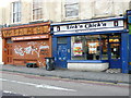
Lick'n Chick'n and Mr Falafel
These two shops, are on the east side of Stokes Croft, close to its junction with City Rd. One is a take away the other a health food shop. In Stokes Croft very few surfaces escape the graffiti artist for long.
Image: © Nigel Mykura
Taken: 12 Apr 2013
0.03 miles
7
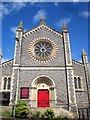
City Road Baptist Chapel, Bristol
Also shown at http://www.geograph.org.uk/search.php?i=57230227 . The church dates from 1861. "W front has a tall central gable with a Lombard frieze, parapet with rope moulding and a central square pinnacle, flanked by clasping buttresses forming small turrets with octagonal pinnacles; a semicircular-arched door of 3 orders has foliate capitals to shafts, foliate decoration to the inner arches and rope and flowers to the outer; shoulder-arch door and CITY ROAD BAPTIST CHAPEL 1862 in the tympanum; a band runs across above the door reading STRIVE TO ENTER IN AT THE STRAIT GATE, below a wheel window with 12 trefoil-headed lights and polychrome voussoirs" http://list.historicengland.org.uk/resultsingle.aspx?uid=1202082&searchtype=mapsearch
Image: © Derek Harper
Taken: 29 Jul 2015
0.03 miles
8
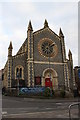
City Road Baptist Church from Upper York Street
There is an OS benchmark Image on the buttress at the left hand corner of the church
Image: © Roger Templeman
Taken: 4 Feb 2018
0.03 miles
9
Corner of City Road and the A38 in Stokes Croft
With more of the colourful murals which adorn the city of Bristol.
Image: © Eirian Evans
Taken: 29 Jul 2011
0.03 miles
10
Upper York Street, Bristol
Looking past the junction with Backfields Lane, the former faggot factory of H H Brain, and the Door and Rivet cafe, to the City Road Baptist Church https://www.historicengland.org.uk/listing/the-list/list-entry/1202082 .
Image: © Derek Harper
Taken: 29 Nov 2017
0.03 miles