IMAGES TAKEN NEAR TO
Hillgrove Street North, BRISTOL, BS2 8LT
Introduction
This page details the photographs taken nearby to Hillgrove Street North, BS2 8LT by members of the Geograph project.
The Geograph project started in 2005 with the aim of publishing, organising and preserving representative images for every square kilometre of Great Britain, Ireland and the Isle of Man.

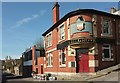
There are currently over 7.5m images from over14,400 individuals and you can help contribute to the project by visiting https://www.geograph.org.uk
Image Map
Images are licensed for reuse under creativecommons.org/licenses/by-sa/2.0
Notes
- Clicking on the map will re-center to the selected point.
- The higher the marker number, the further away the image location is from the centre of the postcode.
Image Listing (484 Images Found)
Images are licensed for reuse under creativecommons.org/licenses/by-sa/2.0
Image
Details
Distance
1
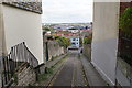
Narrow street in Kingsdown
The street leading down to Dove Street is unnamed. Beyond is a view over part of Bristol city centre including Cabot Circus.
Image: © Bill Boaden
Taken: 15 Apr 2017
0.01 miles
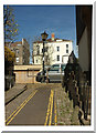
2
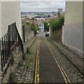
Looking down Hillgrove Street North, Kingsdown, Bristol
A closed-off steep narrow street between Somerset Street and Dove Street.
Image: © Robin Stott
Taken: 24 Jun 2017
0.01 miles
3
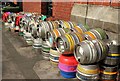
Beer kegs, Bristol
Outside the Hillgrove Porter Stores Image
Image: © Derek Harper
Taken: 20 Apr 2016
0.01 miles
4
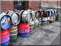
Lots of flavours at this pub
A colourful scene outside the Hillgrove Porter Stores pub on Dove Street. Note the cable tying them all together until the lorry arrives.
Image: © Neil Owen
Taken: 25 Apr 2019
0.01 miles
5
The Hillgrove, Bristol
The Hillgrove Porter Stores is on Dove Street at the foot of Hillgrove Street North (right).
Image: © Derek Harper
Taken: 20 Apr 2016
0.01 miles
6
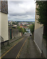
Looking down Hillgrove Street North, Kingsdown, Bristol
A closed-off steep narrow street between Somerset Street and Dove Street.
Image: © Robin Stott
Taken: 24 Jun 2017
0.01 miles
7
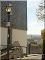
Hillgrove Street North, Bristol
Not a street you can drive down, being blocked off to the left of the camera at its junction with Somerset Street. Prominent below is the tower of the Church of St Paul https://www.historicengland.org.uk/listing/the-list/list-entry/1292368 .
Image: © Derek Harper
Taken: 20 Apr 2016
0.01 miles
8
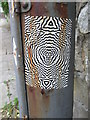
An odd thing on a lamppost
Although much of this area of Bristol is a blank canvas for many styles of artist, this design seems a little out of context. Or possibly the lamppost is the one out of context.
Image: © Neil Owen
Taken: 25 Apr 2019
0.01 miles
9
Hillgrove Street North, Bristol
A reverse view of Image], with the blocked-off top of the steep street. Ahead in Image is a pair of attached houses on Kingsdown Parade.
Image: © Derek Harper
Taken: 20 Apr 2016
0.02 miles
10

Ordnance Survey Cut Mark
This OS cut mark can be found on the wall of No29 Somerset Street. It marks a point 56.318m above mean sea level.
Image: © Adrian Dust
Taken: 14 Mar 2020
0.02 miles