IMAGES TAKEN NEAR TO
Portland Street, BRISTOL, BS2 8HL
Introduction
This page details the photographs taken nearby to Portland Street, BS2 8HL by members of the Geograph project.
The Geograph project started in 2005 with the aim of publishing, organising and preserving representative images for every square kilometre of Great Britain, Ireland and the Isle of Man.

There are currently over 7.5m images from over14,400 individuals and you can help contribute to the project by visiting https://www.geograph.org.uk
Image Map
Images are licensed for reuse under creativecommons.org/licenses/by-sa/2.0
Notes
- Clicking on the map will re-center to the selected point.
- The higher the marker number, the further away the image location is from the centre of the postcode.
Image Listing (363 Images Found)
Images are licensed for reuse under creativecommons.org/licenses/by-sa/2.0
Image
Details
Distance
1
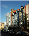
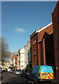
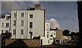
Houses on Portland Street, Kingsdown
On the left is a pair of attached listed houses https://www.historicengland.org.uk/listing/the-list/list-entry/1279579 , with Cotham Road just beyond.
Image: © Derek Harper
Taken: 4 Apr 2018
0.01 miles
2
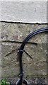
Ordnance Survey Cut Mark
This OS cut mark can be found on the Lutton Memorial Hall. It marks a point 70.601m above mean sea level.
Image: © Adrian Dust
Taken: 29 Feb 2016
0.01 miles
3
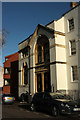
Lutton Memorial Hall
This now forms part of Knightstone House, the 1978 brick building on the left. That was built on the site of the demolished Portland Street Wesleyan Chapel (1792), where "Miss Anne Lutton was ... an eloquent preacher ... She was blind for nearly twenty years prior to her death on 22nd August 1881 at the age of ninety. In 1883 the Chapel decided to erect the Lutton Memorial Hall" http://allkhra.blogspot.co.uk/2007/06/snippets-from-past-issues.html .
Image: © Derek Harper
Taken: 4 Apr 2018
0.01 miles
4
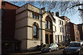
Lutton Memorial Hall
A view of Image] from a little further down the street. "Miss Anne Lutton was for many years an eloquent preacher" http://allkhra.blogspot.co.uk/2007/06/snippets-from-past-issues.html at the Portland Street Wesleyan Chapel next door, now demolished, "to her own sex throughout England and Ireland and spoke several languages. She was blind for nearly twenty years prior to her death on 22nd August 1881 at the age of ninety. In 1883 the Chapel decided to erect the Lutton Memorial Hall" .
To the right are the three listed buildings described at https://www.historicengland.org.uk/listing/the-list/list-entry/1202451 and https://www.historicengland.org.uk/listing/the-list/list-entry/1202452 .
Image: © Derek Harper
Taken: 4 Apr 2018
0.01 miles
5
Portland Street, Kingsdown
Looking left from where Image] was taken. On the right are modern flats at Knightstone Walk; further down the street is a corner of Knightstone House, also brick, and built on the site of Portland Wesleyan Chapel, demolished in 1971. The building incorporates the gabled building, which is the former Lutton Memorial Hall (1883). On this side are three listed buildings described at https://www.historicengland.org.uk/listing/the-list/list-entry/1202451 and https://www.historicengland.org.uk/listing/the-list/list-entry/1202452 .
Down at the far end of the street is the T junction with Cotham Road.
Image: © Derek Harper
Taken: 4 Apr 2018
0.02 miles
6
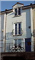
House on Portland Street, Kingsdown
With a bike attached to railings on the raised pavement.
Image: © Derek Harper
Taken: 4 Apr 2018
0.02 miles
7
Junction, Kingsdown
Montague Place meets Henrietta Street (left) and becomes Cotham Road South. Beyond is the scene in Image
Image: © Derek Harper
Taken: 15 Jun 2018
0.02 miles
8
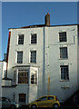
Listed buildings, Portland Street, Kingsdown
Kingsley House and Ebenezer House are described at https://www.historicengland.org.uk/listing/the-list/list-entry/1279579 . They are also shown on the left of Image
Image: © Derek Harper
Taken: 4 Apr 2018
0.03 miles
9
Listed buildings, Kingsdown
The rear of the buildings shown from the other side in Image https://www.historicengland.org.uk/listing/the-list/list-entry/1279579 . This road is Cotham Road South.
Image: © Derek Harper
Taken: 15 Jun 2018
0.03 miles
10
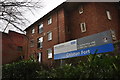
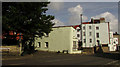
Bristol : Colston Fort
Community Drug and Alcohol Services are provided here.
Image: © Lewis Clarke
Taken: 24 Mar 2015
0.03 miles