IMAGES TAKEN NEAR TO
Eugene Street, BRISTOL, BS2 8EU
Introduction
This page details the photographs taken nearby to Eugene Street, BS2 8EU by members of the Geograph project.
The Geograph project started in 2005 with the aim of publishing, organising and preserving representative images for every square kilometre of Great Britain, Ireland and the Isle of Man.

There are currently over 7.5m images from over14,400 individuals and you can help contribute to the project by visiting https://www.geograph.org.uk
Image Map
Images are licensed for reuse under creativecommons.org/licenses/by-sa/2.0
Notes
- Clicking on the map will re-center to the selected point.
- The higher the marker number, the further away the image location is from the centre of the postcode.
Image Listing (665 Images Found)
Images are licensed for reuse under creativecommons.org/licenses/by-sa/2.0
Image
Details
Distance
1
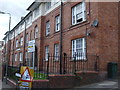
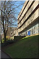
Montague Flats
One of three of a large and impressive row of flats close to the hospital. Close to the green utility box is a benchmark - see Image
Image: © Neil Owen
Taken: 25 Apr 2019
0.00 miles
2
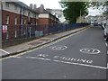
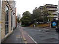
Road where the smoking stops
Montague Hill South: the road leads up to part of the hospital complex in the centre of Bristol. It just so happens that the section nearest the camera is council property, whereas the upper is officially part of the hospital trust. Hence, the rules of the road, the parking rules and the environmental restrictions change right on the white line.
Image: © Neil Owen
Taken: 25 Apr 2019
0.01 miles
3
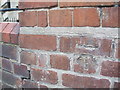
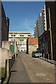
Benchmark in Eugene Street
Partly filled in with concrete, this benchmark is listed in the Benchmark Database: https://www.bench-marks.org.uk/bm86481 . See Image] for a wider view of the flats.
Image: © Neil Owen
Taken: 25 Apr 2019
0.01 miles
4
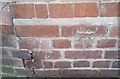
Ordnance Survey Cut Mark
This OS cut mark can be found on the east angle of Montague Flats. It marks a point 29.005m above mean sea level.
Image: © Adrian Dust
Taken: 26 Jan 2020
0.01 miles
5
Princess Row, Bristol
A reverse view of Image], looking up the cobbled street towards Carolina House.
Image: © Derek Harper
Taken: 20 Apr 2016
0.01 miles
6
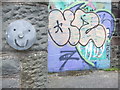
A welcoming smile
The graffiti is merely complimentary.
Image: © Neil Owen
Taken: 25 Apr 2019
0.02 miles
7
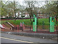
Dove Street South play area
A semicircular patch for the many occupants of the towering blocks of flats to play in.
Image: © Neil Owen
Taken: 25 Apr 2019
0.03 miles
8
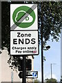
Charges stop here
For all those driving a non-compliant vehicle, this payment zone sign must be a welcome sight.
Image: © Neil Owen
Taken: 25 Sep 2023
0.03 miles
9
Offices by Dighton Street, Bristol
These are the headquarters of the University Hospitals Bristol NHS Foundation Trust.
Image: © Derek Harper
Taken: 20 Apr 2016
0.03 miles
10
Montague Street/Montague Hill junction
On Dighton Street (B4051).
Image: © Hamish Griffin
Taken: 11 Nov 2014
0.03 miles