IMAGES TAKEN NEAR TO
Park Lane, BRISTOL, BS2 8BE
Introduction
This page details the photographs taken nearby to Park Lane, BS2 8BE by members of the Geograph project.
The Geograph project started in 2005 with the aim of publishing, organising and preserving representative images for every square kilometre of Great Britain, Ireland and the Isle of Man.

There are currently over 7.5m images from over14,400 individuals and you can help contribute to the project by visiting https://www.geograph.org.uk
Image Map
Images are licensed for reuse under creativecommons.org/licenses/by-sa/2.0
Notes
- Clicking on the map will re-center to the selected point.
- The higher the marker number, the further away the image location is from the centre of the postcode.
Image Listing (997 Images Found)
Images are licensed for reuse under creativecommons.org/licenses/by-sa/2.0
Image
Details
Distance
1
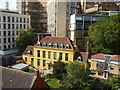
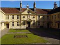
The Manor House on Park Place
The yellowish building is the Manor House, a seventeenth century Grade II listed gem that used to be nestled in a quiet part near the city centre. It is now a superior renovation for student accommodation. However, by the end of the twentieth century the massive blocks of the University Chemistry and Medical departments have loomed over it; the Manor House now looks like a display in a model village.
Image: © Neil Owen
Taken: 15 Sep 2019
0.00 miles
2
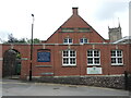
St Michael on the Mount Without Memorial Parish Hall
The modern hall is less than a century old but has a floor of about 144 m sq (1550 sq ft).
Image: © Neil Owen
Taken: 10 Sep 2024
0.02 miles
3
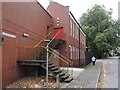
Not a public highway
The sign looks as though the road and pavement might not be accessible, although this is on Medical Avenue.
Image: © Neil Owen
Taken: 10 Sep 2024
0.03 miles
4
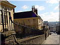
Looking down St Michael's Hill past the Almshouse
Looking south down St Michael's Hill past the railings outside Colston's Almshouse.
Image: © Linda Bailey
Taken: 6 Mar 2006
0.03 miles
5
Colston's Almshouse
Looking east through the railings Image at Colston's Almshouse which was built in 1691. It was founded by Edward Colston, and the 12 men and women residents had to be born in Bristol and attend the chapel regularly.
Image: © Linda Bailey
Taken: 6 Mar 2006
0.03 miles
6
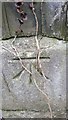
Ordnance Survey Cut Mark
This OS cut mark can be found on the NW face of St Michael's Church. It marks a point 44.946m above mean sea level.
Image: © Adrian Dust
Taken: 29 Feb 2016
0.03 miles
7
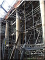
Scaffolding inside St Michael on the Mount Without
The fire of 2016 caused a great deal of damage to the disused church, and the loss of the roof has allowed a continuing deterioration inside as well as out. Now an attempt to restore the building is under way, with plans to create an art and events venue.
Image: © Neil Owen
Taken: 15 Sep 2019
0.03 miles
8
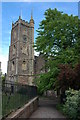
St Michael-on-the-Mount-Without, Bristol
St Michael on the Mount Without is situated on St Michael's Hill in Bristol. The tower dates from the 15th century, the church was rebuilt in the late 18th century. Sadly the church is now boarded up.
Image: © Philip Halling
Taken: 12 May 2007
0.03 miles
9
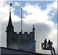
Firefighters, St Michael on the Mount church, Bristol
Smoke from the burning building https://www.historicengland.org.uk/listing/the-list/list-entry/1282109 immerses these two firefighters at the top of an extended ladder. See also http://www.geograph.org.uk/search.php?i=66666040 .
Image: © Derek Harper
Taken: 16 Oct 2016
0.03 miles
10
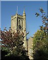
St Michael on the Mount church, Bristol
At first glance, an idyllic sunny scene of a church tower https://www.historicengland.org.uk/listing/the-list/list-entry/1282109 . But there's a huge hole in the roof and smoke is rising. See also http://www.geograph.org.uk/search.php?i=66666040 .
Image: © Derek Harper
Taken: 16 Oct 2016
0.03 miles