IMAGES TAKEN NEAR TO
King Square, BRISTOL, BS2 8AZ
Introduction
This page details the photographs taken nearby to King Square, BS2 8AZ by members of the Geograph project.
The Geograph project started in 2005 with the aim of publishing, organising and preserving representative images for every square kilometre of Great Britain, Ireland and the Isle of Man.

There are currently over 7.5m images from over14,400 individuals and you can help contribute to the project by visiting https://www.geograph.org.uk
Image Map
Images are licensed for reuse under creativecommons.org/licenses/by-sa/2.0
Notes
- Clicking on the map will re-center to the selected point.
- The higher the marker number, the further away the image location is from the centre of the postcode.
Image Listing (631 Images Found)
Images are licensed for reuse under creativecommons.org/licenses/by-sa/2.0
Image
Details
Distance
1
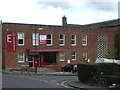
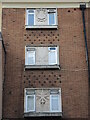
The Kings Community and Conference Centre
The building dates from the 1950s, constructed after the Blitz had destroyed a boot and shoe factory that was here previously. Post-war the Bristol Institute for the Deaf operated from the site. The E5 Elim Pentecostal Church also resides here.
Image: © Neil Owen
Taken: 25 Apr 2019
0.01 miles
2
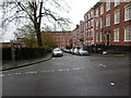
King Square (east street)
From Dove Street South. The park "King Square" is on the left of the street.
Image: © Hamish Griffin
Taken: 11 Nov 2014
0.02 miles
4
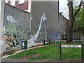
Dove Street South designs
More local colour to confuse or bemuse.
Image: © Neil Owen
Taken: 25 Apr 2019
0.02 miles
5
Church Army weapons
Fighting the Good Fight requires a Helmet of Salvation, the Shield of Faith and the Sword of the Spirit. All three emblems are part of the south side of the old Church Army Hotel in Jamaica Street. See Image] for more details.
Image: © Neil Owen
Taken: 11 Oct 2022
0.02 miles
6
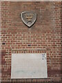
Church Army foundation stone
The building on Jamaica Street was opened in 1954 to provide shelter. See Image] for a wider view or Image] for some details on the south wall.
Image: © Neil Owen
Taken: 11 Oct 2022
0.02 miles
7
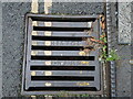
A Bristol Sewers grating
There are still a few of these old irons on the older streets in town. And as it happened, there was a rather foul smell around it - hopefully not due to grey water going into the storm systems.
Image: © Neil Owen
Taken: 11 Oct 2022
0.03 miles
8
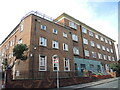
Reusing the Church Army hostel
A new brick building on King Square and Jamaica Street is the old Church Army hostel, now run by the Riverside organisation. The C.A. opened this place for the homeless in 1954 - see Image] for a foundation stone at this corner. Riverside was originally the Liverpool Improved Houses, a help group founded in 1928 and which has successively been amalgamated and gathered other local housing groups. It now runs this hostel in Bristol following a major refurishment in the mid 2010s.
The site was previously the Coe, Church and McPherson Boot and Shoe factory, a ladies bootmaker for about a century.
Image: © Neil Owen
Taken: 11 Oct 2022
0.03 miles
9
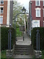
A long climb up from Kings Square
Part of Bristol's more elaborate urban scenery, there are several flights of steps leading from the low ground of the square up the steep hillside. This one leads up Spring Hill.
Image: © Neil Owen
Taken: 25 Apr 2019
0.03 miles
10
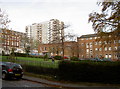
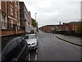
Kings Square
Looking north towards the high-rise flats of Stokes Croft.
Image: © Neil Owen
Taken: 23 Nov 2011
0.03 miles