IMAGES TAKEN NEAR TO
Pembroke Street, BRISTOL, BS2 8AH
Introduction
This page details the photographs taken nearby to Pembroke Street, BS2 8AH by members of the Geograph project.
The Geograph project started in 2005 with the aim of publishing, organising and preserving representative images for every square kilometre of Great Britain, Ireland and the Isle of Man.

There are currently over 7.5m images from over14,400 individuals and you can help contribute to the project by visiting https://www.geograph.org.uk
Image Map
Images are licensed for reuse under creativecommons.org/licenses/by-sa/2.0
Notes
- Clicking on the map will re-center to the selected point.
- The higher the marker number, the further away the image location is from the centre of the postcode.
Image Listing (581 Images Found)
Images are licensed for reuse under creativecommons.org/licenses/by-sa/2.0
Image
Details
Distance
1
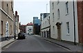
Pembroke Street, Bristol
From the junction with Gloucester Street and Brunswick Square. On the right is a house described as part of number 26, Gloucester Street, at https://www.historicengland.org.uk/listing/the-list/list-entry/1282273 . The modern, glass, Spectrum House is a little further along on the right; it also faces Newfoundland Street (see Image).
Image: © Derek Harper
Taken: 10 Jun 2016
0.01 miles
2
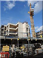
New on Surrey Street
An old warehouse has been flattened and some new building work is under way, presumably for housing rather than commercial use.
Image: © Neil Owen
Taken: 13 Sep 2023
0.03 miles
3
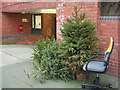
Christmas trees, Bristol
Always a rather sad sight. Still, I'm sure Bristol Council will know how to recycle them in the most environmentally-friendly way. These, plus an office chair to accommodate any passers-by who might wish to cheer them up, are on Surrey Street.
Image: © Derek Harper
Taken: 5 Jan 2019
0.03 miles
4
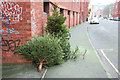
Christmas trees, Bristol
A view of Image from the other direction, with Surrey Street in the background.
Image: © Derek Harper
Taken: 5 Jan 2019
0.03 miles
5
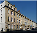
1-6 Portland Square, Bristol
At the south-west corner of this plain but stately Georgian square, laid out, with the surrounding streets, by the architect Daniel Hague from c1787 (though not completed until c1823). Each house, in Bath stone, is of three storeys plus basement and attic (the end a storey higher), rusticated ground floor, and good pedimented doorcase. Grade I listed.
I think now all in commercial use.
Image: © Stephen Richards
Taken: 23 May 2012
0.03 miles
6
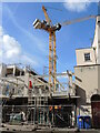
A crane on Surrey Street
The old food warehouse is now gone and the site being rebuilt, with a taller structure than before.
Image: © Neil Owen
Taken: 13 Sep 2023
0.03 miles
7
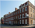
7-12 Brunswick Square, Bristol
Each of the square's sides are different. The east side is a brick terrace - fairly unusual for Bristol - dating from c1784, its architect probably William Paty. The houses have his usual stepped voussoirs. The end are emphasised but not the centre. Grade II listed.
Now all offices I think.
Image: © Stephen Richards
Taken: 23 May 2012
0.03 miles
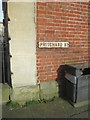
8
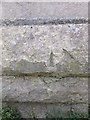
Ordnance Survey Bench Mark
This damaged OS bench mark can be found on the corner of Pritchard Street. It marks a point 49.8ft above mean sea level. http://www.geograph.org.uk/photo/4853470
Image: © Adrian Dust
Taken: 3 Mar 2016
0.04 miles
9
Two Ordnance Survey Bench Marks
One faded cut mark below the sign for Pritchard Street and another, very damaged on the stonework bottom left. http://www.geograph.org.uk/photo/4853466
Image: © Adrian Dust
Taken: 3 Mar 2016
0.04 miles
10
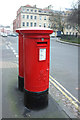
Postboxes, Portland Square, Bristol
The nearer, George V, postbox is numbered BS2 2292. The junction is with Surrey Street. The terrace in the background is listed grade I https://historicengland.org.uk/listing/the-list/list-entry/1202444 but the end house is also at risk https://historicengland.org.uk/advice/heritage-at-risk/search-register/list-entry/49868 .
Image: © Derek Harper
Taken: 5 Jan 2019
0.04 miles