IMAGES TAKEN NEAR TO
Sand Road, WEDMORE, BS28 4XH
Introduction
This page details the photographs taken nearby to Sand Road, BS28 4XH by members of the Geograph project.
The Geograph project started in 2005 with the aim of publishing, organising and preserving representative images for every square kilometre of Great Britain, Ireland and the Isle of Man.

There are currently over 7.5m images from over14,400 individuals and you can help contribute to the project by visiting https://www.geograph.org.uk
Image Map
Images are licensed for reuse under creativecommons.org/licenses/by-sa/2.0
Notes
- Clicking on the map will re-center to the selected point.
- The higher the marker number, the further away the image location is from the centre of the postcode.
Image Listing (2 Images Found)
Images are licensed for reuse under creativecommons.org/licenses/by-sa/2.0
Image
Details
Distance
1
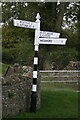
Direction Sign ? Signpost in Sand
Located on the south side of the T junction with Sand Lane in Sand, Wedmore parish. 3 arms and pyramid spear finial. See also http://www.flickr.com/photos/13171205@N08/8371982210 before it was restored.
Milestone Society National ID: SO_ST4346
Image: © R Raynsford
Taken: 13 Oct 2020
0.16 miles
2
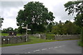
Sand
These field entrance gates are at the road junction at the centre of this tiny hamlet.There is a village notice board advertising nothing but cider next to the signpost showing the routes to Blackford and Glastonbury.
Image: © Nigel Mykura
Taken: 5 Aug 2015
0.18 miles