IMAGES TAKEN NEAR TO
Mudgley Cross Roads, WEDMORE, BS28 4TW
Introduction
This page details the photographs taken nearby to Mudgley Cross Roads, BS28 4TW by members of the Geograph project.
The Geograph project started in 2005 with the aim of publishing, organising and preserving representative images for every square kilometre of Great Britain, Ireland and the Isle of Man.

There are currently over 7.5m images from over14,400 individuals and you can help contribute to the project by visiting https://www.geograph.org.uk
Image Map
Images are licensed for reuse under creativecommons.org/licenses/by-sa/2.0
Notes
- Clicking on the map will re-center to the selected point.
- The higher the marker number, the further away the image location is from the centre of the postcode.
Image Listing (3 Images Found)
Images are licensed for reuse under creativecommons.org/licenses/by-sa/2.0
Image
Details
Distance
2
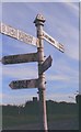
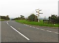
Direction Sign - Signpost on the B3151 Mudgley Hill
Pyramid finial - 5 arms; Somerset SCC pyramid by the B3151, in parish of Wedmore (Sedgemoor District), on the southwest side of the crossroads of the B3151 Mudgley Hill and lanes to Sand and Bagley.
surveyed
Milestone Society National ID: SO_ST4446
Image: © Milestone Society
Taken: Unknown
0.11 miles
3
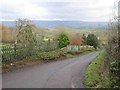
Lane down to Levels
This lane goes NE from Mudgley down to the Somerset Levels. The Mendips are in the background
Image: © Graham Richards
Taken: 27 Dec 2005
0.22 miles