IMAGES TAKEN NEAR TO
Snake Lane, WEDMORE, BS28 4SZ
Introduction
This page details the photographs taken nearby to Snake Lane, BS28 4SZ by members of the Geograph project.
The Geograph project started in 2005 with the aim of publishing, organising and preserving representative images for every square kilometre of Great Britain, Ireland and the Isle of Man.

There are currently over 7.5m images from over14,400 individuals and you can help contribute to the project by visiting https://www.geograph.org.uk
Image Map (Loading...)


Getting Data...Please wait
Leaflet Map data © OpenStreetMap
Images are licensed for reuse under creativecommons.org/licenses/by-sa/2.0
Notes
- Clicking on the map will re-center to the selected point.
- The higher the marker number, the further away the image location is from the centre of the postcode.
Image Listing (10 Images Found)
Images are licensed for reuse under creativecommons.org/licenses/by-sa/2.0
Image
Details
Distance
1
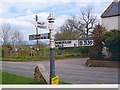
Old Direction Sign - Signpost by the B3139, Wells Road, Theale
Pyramid finial - 3 arms; Somerset SCC pyramid by the B3139, in parish of Wedmore (Sedgemoor District), junction with Snake Lane, Theale.
Surveyed
Milestone Society National ID: SO_ST4646
Image: © Milestone Society
Taken: Unknown
0.02 miles
3
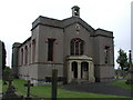
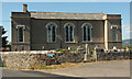
THEALE, Somerset
The odd church by Richard Carver built in 1829, dedicated Christ Church. See also Blackford.
Image: © ChurchCrawler
Taken: 20 Jul 2004
0.08 miles
4
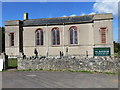
Christ Church, Theale
Looking across the B3139. The church, also shown at http://www.geograph.org.uk/search.php?i=85395212 , is described at https://www.historicengland.org.uk/listing/the-list/list-entry/1262045 : "Gothick Revival".
Image: © Derek Harper
Taken: 8 Jul 2018
0.09 miles
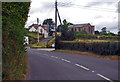
6
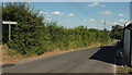
B3139 at Theale
But entering Panborough; the villages run into one another.
Image: © Derek Harper
Taken: 8 Jul 2018
0.11 miles
8
B3139 towards Theale
Christchurch, Theale can be seen ahead.
Image: © J.Hannan-Briggs
Taken: 31 Jul 2014
0.18 miles
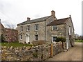
9
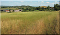
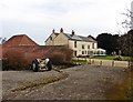
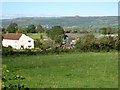
Farmland at Theale
With Garden End Farm (in Image and Image) on the left. Taken from near Christ Church by the B3139. The village against the hill beyond is Henton; Barrow Hill is on the right.
Image: © Derek Harper
Taken: 8 Jul 2018
0.21 miles