IMAGES TAKEN NEAR TO
Theale, WEDMORE, BS28 4SN
Introduction
This page details the photographs taken nearby to BS28 4SN by members of the Geograph project.
The Geograph project started in 2005 with the aim of publishing, organising and preserving representative images for every square kilometre of Great Britain, Ireland and the Isle of Man.

There are currently over 7.5m images from over14,400 individuals and you can help contribute to the project by visiting https://www.geograph.org.uk
Image Map
Images are licensed for reuse under creativecommons.org/licenses/by-sa/2.0
Notes
- Clicking on the map will re-center to the selected point.
- The higher the marker number, the further away the image location is from the centre of the postcode.
Image Listing (6 Images Found)
Images are licensed for reuse under creativecommons.org/licenses/by-sa/2.0
Image
Details
Distance
1
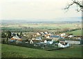
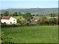
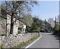
Theale village
Ancient stone houses mix with new development in this typical Somerset Levels village. In the middle distance, the flood plain of the River Axe extends for two-to-three miles towards Cheddar Gorge and the Mendip Hills
Image: © Flying Stag
Taken: Unknown
0.04 miles
3
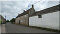
Oak Tree Farmhouse
https://historicengland.org.uk/listing/the-list/list-entry/1262002?section=official-list-entry
Image: © Sandy Gerrard
Taken: 30 May 2024
0.04 miles
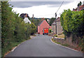
5
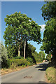
B3139 at Theale
Wells Road passing farms and cottages as it approaches the centre of the village from the west.
Image: © Derek Harper
Taken: 8 Jul 2018
0.21 miles