IMAGES TAKEN NEAR TO
Latcham, WEDMORE, BS28 4SD
Introduction
This page details the photographs taken nearby to BS28 4SD by members of the Geograph project.
The Geograph project started in 2005 with the aim of publishing, organising and preserving representative images for every square kilometre of Great Britain, Ireland and the Isle of Man.

There are currently over 7.5m images from over14,400 individuals and you can help contribute to the project by visiting https://www.geograph.org.uk
Image Map
Images are licensed for reuse under creativecommons.org/licenses/by-sa/2.0
Notes
- Clicking on the map will re-center to the selected point.
- The higher the marker number, the further away the image location is from the centre of the postcode.
Image Listing (1 Images Found)
Images are licensed for reuse under creativecommons.org/licenses/by-sa/2.0
Image
Details
Distance
1
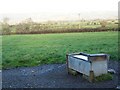
Grazing near Bagley
An area of lush fields. At least the cattle will not get their feet muddy as the area around the water trough has been made firm with road scalpings.
Image: © Maigheach-gheal
Taken: 17 Jan 2010
0.23 miles