IMAGES TAKEN NEAR TO
Lascot Hill, WEDMORE, BS28 4QU
Introduction
This page details the photographs taken nearby to Lascot Hill, BS28 4QU by members of the Geograph project.
The Geograph project started in 2005 with the aim of publishing, organising and preserving representative images for every square kilometre of Great Britain, Ireland and the Isle of Man.

There are currently over 7.5m images from over14,400 individuals and you can help contribute to the project by visiting https://www.geograph.org.uk
Image Map (Loading...)


Getting Data...Please wait
Leaflet Map data © OpenStreetMap
Images are licensed for reuse under creativecommons.org/licenses/by-sa/2.0
Notes
- Clicking on the map will re-center to the selected point.
- The higher the marker number, the further away the image location is from the centre of the postcode.
Image Listing (4 Images Found)
Images are licensed for reuse under creativecommons.org/licenses/by-sa/2.0
Image
Details
Distance
1
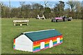
Horse jumps at Mill Farm
Looks like someone had a lot of fun building these.
Image: © David Martin
Taken: 19 Feb 2023
0.11 miles
2
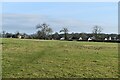
Path across field to northern edge of Wedmore
Image: © David Martin
Taken: 19 Feb 2023
0.24 miles
4
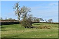
Field with damp area, just north of Wedmore
No seasonal ponds are marked on the map, but there are clearly some damp hollows here that drain to the left hand side of the field, where there is a small footbridge.
Image: © David Martin
Taken: 19 Feb 2023
0.24 miles