IMAGES TAKEN NEAR TO
Church Lane, WEDMORE, BS28 4NS
Introduction
This page details the photographs taken nearby to Church Lane, BS28 4NS by members of the Geograph project.
The Geograph project started in 2005 with the aim of publishing, organising and preserving representative images for every square kilometre of Great Britain, Ireland and the Isle of Man.

There are currently over 7.5m images from over14,400 individuals and you can help contribute to the project by visiting https://www.geograph.org.uk
Image Map (Loading...)


Getting Data...Please wait
Leaflet Map data © OpenStreetMap
Images are licensed for reuse under creativecommons.org/licenses/by-sa/2.0
Notes
- Clicking on the map will re-center to the selected point.
- The higher the marker number, the further away the image location is from the centre of the postcode.
Image Listing (30 Images Found)
Images are licensed for reuse under creativecommons.org/licenses/by-sa/2.0
Image
Details
Distance
3
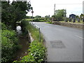
The Blackford Brook by the church
Approaching the village from the west, the brook departs in the opposite direction.
Image: © Neil Owen
Taken: 27 May 2024
0.06 miles
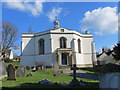
4
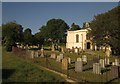
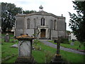
Holy Trinity Church, Blackford
This view of the church shown in http://www.geograph.org.uk/gridref/ST4047?centi=ST408477 and its churchyard is from the stile at the start of footpath AX 27/57. The church is described at http://list.english-heritage.org.uk/resultsingle.aspx?uid=1252629&searchtype=mapsearch .
Image: © Derek Harper
Taken: 3 Jun 2013
0.06 miles
5
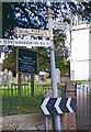
Old Direction Sign - Signpost by the B3139, Church Street, Wedmore parish
Pyramid finial - 3 arms; Somerset SCC pyramid by the B3139, in parish of Wedmore (Sedgemoor District), Church Street junction with Poolebridge Road, Blackford.
Surveyed
Milestone Society National ID: SO_ST4047
Image: © Milestone Society
Taken: Unknown
0.06 miles
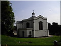
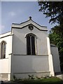
6
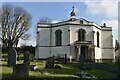
Holy Trinity Church, Blackford
The core of the building is based on an unusual octagonal plan.
Image: © David Martin
Taken: 19 Feb 2023
0.07 miles
7
BLACKFORD, Somerset
The unusual sort-of-octagonal church of the Holy Trinity
Image: © ChurchCrawler
Taken: 20 Jul 2004
0.07 miles
9
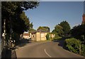
Junction, Blackford
From the same spot as Image], looking to the right. The B3139 swings right past the start of Church Street. On the corner is the former schoolroom http://list.english-heritage.org.uk/resultsingle.aspx?uid=1252632&searchtype=mapsearch , by the same architect as the church across the street, and now mapped as a hall. "Tudor Gothic Revival".
Image: © Derek Harper
Taken: 3 Jun 2013
0.08 miles