IMAGES TAKEN NEAR TO
Crickham, WEDMORE, BS28 4JT
Introduction
This page details the photographs taken nearby to BS28 4JT by members of the Geograph project.
The Geograph project started in 2005 with the aim of publishing, organising and preserving representative images for every square kilometre of Great Britain, Ireland and the Isle of Man.

There are currently over 7.5m images from over14,400 individuals and you can help contribute to the project by visiting https://www.geograph.org.uk
Image Map (Loading...)


Getting Data...Please wait
Leaflet Map data © OpenStreetMap
Images are licensed for reuse under creativecommons.org/licenses/by-sa/2.0
Notes
- Clicking on the map will re-center to the selected point.
- The higher the marker number, the further away the image location is from the centre of the postcode.
Image Listing (20 Images Found)
Images are licensed for reuse under creativecommons.org/licenses/by-sa/2.0
Image
Details
Distance
3
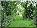
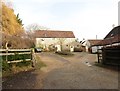
Footpath between Crickham and Stoughton
Image: © David Purchase
Taken: 10 Aug 2011
0.17 miles
4

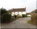
Turbine near Pear Tree Farm
Rural technology in the field.
Image: © Neil Owen
Taken: 5 Feb 2023
0.18 miles
6
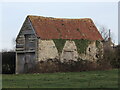
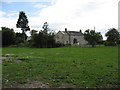
Old barn near Stoughton Cross
Some rustic flavour in the field.
Image: © Neil Owen
Taken: 5 Feb 2023
0.18 miles
8
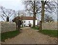
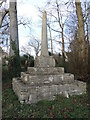
Stoughton Cross
Fifteenth Century wayside cross, beside the cross roads.
Image: © David Martin
Taken: 18 Feb 2023
0.21 miles
9
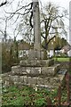
Stoughton's Cross
The crossroads are marked by a stone cross, believed to be fifteenth century. Originally the cross was in the field just a few metres south-east of its present position, and had an abacus head - which is now lost. Grade II* listed.
On the base is a rivet benchmark - see Image
Image: © Neil Owen
Taken: 5 Feb 2023
0.22 miles
10
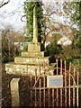
15thc wayside cross at Stoughton
Fitted with a placard since 2006 - Image
Image: © Roger Cornfoot
Taken: 3 Jan 2018
0.22 miles