IMAGES TAKEN NEAR TO
Cheddar Road, WEDMORE, BS28 4ET
Introduction
This page details the photographs taken nearby to Cheddar Road, BS28 4ET by members of the Geograph project.
The Geograph project started in 2005 with the aim of publishing, organising and preserving representative images for every square kilometre of Great Britain, Ireland and the Isle of Man.

There are currently over 7.5m images from over14,400 individuals and you can help contribute to the project by visiting https://www.geograph.org.uk
Image Map (Loading...)


Getting Data...Please wait
Leaflet Map data © OpenStreetMap
Images are licensed for reuse under creativecommons.org/licenses/by-sa/2.0
Notes
- Clicking on the map will re-center to the selected point.
- The higher the marker number, the further away the image location is from the centre of the postcode.
Image Listing (6 Images Found)
Images are licensed for reuse under creativecommons.org/licenses/by-sa/2.0
Image
Details
Distance
2
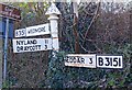
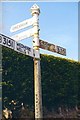
Old Direction Sign - Signpost by the B3151, Cocklake
Pyramid finial - 3 arms; Somerset SCC pyramid by the B3151, in parish of Wedmore (North Somerset District), opposite junction with road to Dungeon and Nyland, West of Cocklake village.
Surveyed
Milestone Society National ID: SO_ST4349A
Image: © Milestone Society
Taken: Unknown
0.15 miles
3
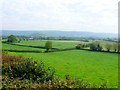
Wedmore Moor
This is the view down on to the moor from the road between Wedmore and Cocklake with the prominent Nyland hill in the background in ST4550 and behind that the line of the Mendip Hills round Cheddar..
Image: © Nigel Mykura
Taken: 16 Sep 2011
0.16 miles
4
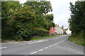
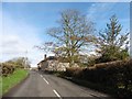
Cheddar Rd
This is the road that leads to Cheddar from Wedmore. The road junction in the foreground is in the village of Cocklake where the minor road runs off to Nyland and Draycott.
Image: © Nigel Mykura
Taken: 5 Aug 2015
0.18 miles
5
Old Direction Sign - Signpost by the B3151, Cheddar Road
Pyramid finial - 4 arms; Somerset SCC pyramid by the B3151, in parish of Wedmore (North Somerset District), Cheddar Road junction with road to Rushill, South of Crickham and West of Cocklake.
Surveyed
Milestone Society National ID: SO_ST4349B.
Image: © Milestone Society
Taken: Unknown
0.21 miles