IMAGES TAKEN NEAR TO
Mudgley Road, WEDMORE, BS28 4DF
Introduction
This page details the photographs taken nearby to Mudgley Road, BS28 4DF by members of the Geograph project.
The Geograph project started in 2005 with the aim of publishing, organising and preserving representative images for every square kilometre of Great Britain, Ireland and the Isle of Man.

There are currently over 7.5m images from over14,400 individuals and you can help contribute to the project by visiting https://www.geograph.org.uk
Image Map (Loading...)


Getting Data...Please wait
Leaflet Map data © OpenStreetMap
Images are licensed for reuse under creativecommons.org/licenses/by-sa/2.0
Notes
- Clicking on the map will re-center to the selected point.
- The higher the marker number, the further away the image location is from the centre of the postcode.
Image Listing (152 Images Found)
Images are licensed for reuse under creativecommons.org/licenses/by-sa/2.0
Image
Details
Distance
1
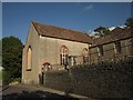
Wedmore Baptist Church
"Probably early C19" http://list.english-heritage.org.uk/resultsingle.aspx?uid=1252643&searchtype=mapsearch . The church is set above Grant's Lane, the B3151.
Image: © Derek Harper
Taken: 3 Jun 2013
0.04 miles
2

Terraced Bungalows
There are two blocks of the terraced bungalows on Grant's Lane. They are very well kept, and the occupants seem to take a pride in them.
Image: © mike smith
Taken: 23 Mar 2012
0.06 miles
3
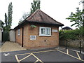
Former Telephone Exchange, Wedmore
Situated in Grant's Lane, this TE, which dates from the GPO era, was replaced by a larger building in Cheddar Road in the early 1970s, ST 4348 refers. This older building is now used as an office by Wedmore Parish Council. Its postcode is BS28 4EA. Tree blossom can be seen to the left of the photo.
Image: © David Hillas
Taken: 14 Apr 2011
0.07 miles
4
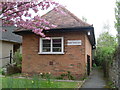
The Parish Rooms
A small brick building is where the local council sits.
Image: © Neil Owen
Taken: 27 May 2024
0.07 miles
5
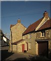
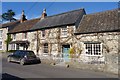
House on Grant's Lane, Wedmore
This listed building is described at http://list.english-heritage.org.uk/resultsingle.aspx?uid=1262185&searchtype=mapsearch as "probably C17". Bridgwood, the house shown in Image], is on the left.
Image: © Derek Harper
Taken: 3 Jun 2013
0.07 miles
6
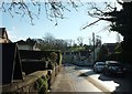
The Borough, Wedmore
The B3139 heading towards a T junction with Grant's Lane, where it turns left along Combe Batch and the Wells Road.
Image: © Derek Harper
Taken: 6 Jan 2016
0.07 miles
7
The Borough, Wedmore
The B3139 approaches the T junction with Grant's Lane (right) and Combe Batch.
Image: © Derek Harper
Taken: 3 Jun 2013
0.08 miles
8
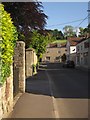
Junction, Wedmore
The T junction seen in Image], with the B3139 turning left along Combe Batch and the B3151 to the right, along Grant's Lane. The building on the right is the C18 Bridgwood http://list.english-heritage.org.uk/resultsingle.aspx?uid=1252206&searchtype=mapsearch . The white house on the left is Barnards http://list.english-heritage.org.uk/resultsingle.aspx?uid=1252203&searchtype=mapsearch .
Image: © Derek Harper
Taken: 3 Jun 2013
0.08 miles
9
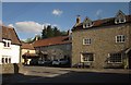
Old Houses on Grants Lane
The village of Wedmore has an abundance of historic houses like these.
Image: © mike smith
Taken: 23 Mar 2012
0.08 miles
10
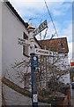
Old Direction Sign - Signpost by The Borough, Wedmore
Pyramid finial - 3 arms; Somerset SCC pyramid by The Borough B3151, in parish of Wedmore (Sedgemoor District) at The Borough junction with Grant's Lane and the B3139 Combe Batch.
Surveyed
Milestone Society National ID: SO_ST4347A
Image: © Milestone Society
Taken: Unknown
0.08 miles