IMAGES TAKEN NEAR TO
Westfield Lane, CHEDDAR, BS27 3UY
Introduction
This page details the photographs taken nearby to Westfield Lane, BS27 3UY by members of the Geograph project.
The Geograph project started in 2005 with the aim of publishing, organising and preserving representative images for every square kilometre of Great Britain, Ireland and the Isle of Man.

There are currently over 7.5m images from over14,400 individuals and you can help contribute to the project by visiting https://www.geograph.org.uk
Image Map (Loading...)


Getting Data...Please wait
Leaflet Map data © OpenStreetMap
Images are licensed for reuse under creativecommons.org/licenses/by-sa/2.0
Notes
- Clicking on the map will re-center to the selected point.
- The higher the marker number, the further away the image location is from the centre of the postcode.
Image Listing (2 Images Found)
Images are licensed for reuse under creativecommons.org/licenses/by-sa/2.0
Image
Details
Distance
1

Old Direction Sign - Signpost by the A371, Wells Road, Rodney Stoke
Pyramid finial - 1 arm; Somerset SCC pyramid by the UC road, in parish of Rodney Stoke (Mendip District), Millway junction with Wells Road and Westfield.
Surveyed
Milestone Society National ID: SO_ST4849
Image: © Milestone Society
Taken: Unknown
0.10 miles
2
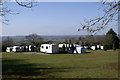
Caravan Park
On Westclose Hill
Image: © Adrian and Janet Quantock
Taken: 19 Mar 2006
0.18 miles