IMAGES TAKEN NEAR TO
Scaddens Lane, CHEDDAR, BS27 3UR
Introduction
This page details the photographs taken nearby to Scaddens Lane, BS27 3UR by members of the Geograph project.
The Geograph project started in 2005 with the aim of publishing, organising and preserving representative images for every square kilometre of Great Britain, Ireland and the Isle of Man.

There are currently over 7.5m images from over14,400 individuals and you can help contribute to the project by visiting https://www.geograph.org.uk
Image Map (Loading...)


Getting Data...Please wait
Leaflet Map data © OpenStreetMap
Images are licensed for reuse under creativecommons.org/licenses/by-sa/2.0
Notes
- Clicking on the map will re-center to the selected point.
- The higher the marker number, the further away the image location is from the centre of the postcode.
Image Listing (8 Images Found)
Images are licensed for reuse under creativecommons.org/licenses/by-sa/2.0
Image
Details
Distance
4
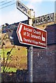
Old Direction Sign - Signpost by the A371, Rodney Stoke
Pyramid finial - 4 arms, 1 Worboys; Somerset SCC pyramid by the A371, in parish of Rodney Stoke (Mendip District), village junction with Stoke Street, Scaden's Lane and Wells Road.
Surveyed
Milestone Society National ID: SO_ST4850
Image: © Milestone Society
Taken: Unknown
0.11 miles
5
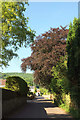
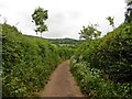
Stoke Street, Rodney Stoke
Across a grid line, with a copper beech by the lane which leads to a crossroads on the A371 Wells Road.
Image: © Derek Harper
Taken: 7 Jul 2018
0.19 miles