IMAGES TAKEN NEAR TO
Rodney Stoke, CHEDDAR, BS27 3UJ
Introduction
This page details the photographs taken nearby to BS27 3UJ by members of the Geograph project.
The Geograph project started in 2005 with the aim of publishing, organising and preserving representative images for every square kilometre of Great Britain, Ireland and the Isle of Man.

There are currently over 7.5m images from over14,400 individuals and you can help contribute to the project by visiting https://www.geograph.org.uk
Image Map
Images are licensed for reuse under creativecommons.org/licenses/by-sa/2.0
Notes
- Clicking on the map will re-center to the selected point.
- The higher the marker number, the further away the image location is from the centre of the postcode.
Image Listing (5 Images Found)
Images are licensed for reuse under creativecommons.org/licenses/by-sa/2.0
Image
Details
Distance
4
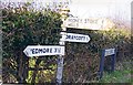
Direction Sign - Signpost on Moor Lane south of Draycott
Pyramid finial - 3 arms; Somerset SCC pyramid by the UC road, in parish of Rodney Stoke (Mendip District), on the northwest side of the T junction of Moor Lane, Brook Lane and Honeyhurst Lane, south of Draycott.
surveyed
Milestone Society National ID: SO_ST4750
Image: © Milestone Society
Taken: Unknown
0.18 miles