IMAGES TAKEN NEAR TO
Card Close, CHEDDAR, BS27 3TZ
Introduction
This page details the photographs taken nearby to Card Close, BS27 3TZ by members of the Geograph project.
The Geograph project started in 2005 with the aim of publishing, organising and preserving representative images for every square kilometre of Great Britain, Ireland and the Isle of Man.

There are currently over 7.5m images from over14,400 individuals and you can help contribute to the project by visiting https://www.geograph.org.uk
Image Map
Images are licensed for reuse under creativecommons.org/licenses/by-sa/2.0
Notes
- Clicking on the map will re-center to the selected point.
- The higher the marker number, the further away the image location is from the centre of the postcode.
Image Listing (25 Images Found)
Images are licensed for reuse under creativecommons.org/licenses/by-sa/2.0
Image
Details
Distance
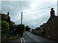
1
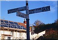
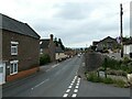
Old Direction Sign - Signpost by the A371, Wells Road, Draycott
Located in Draycott village on the west side of the T junction of the A371 Wells Road and Back Lane, Rodney Stoke parish. 3 arms and lost pyramid finial.
Milestone Society National ID: SO_ST4751B
Image: © J Dowding
Taken: Unknown
0.07 miles
2
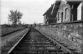
Draycott Railway Station
Picture of the old Draycott Railway station looking west towards the crossing gates in Milking Lane after the closure of passenger services in the mid 1960s. Taken probably around 1967.
Image: © b Lewis
Taken: Unknown
0.09 miles
4
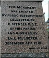
Draycott Memorial: panel three (inscription)
For the full memorial see this photo by Geograph legend Derek Harper https://www.geograph.org.uk/photo/2584594
Image: © Basher Eyre
Taken: 18 Aug 2023
0.11 miles
6
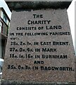
Draycott Memorial: panel one (inscription)
For the full memorial see this photo by Geograph legend Derek Harper https://www.geograph.org.uk/photo/2584594
Image: © Basher Eyre
Taken: 18 Aug 2023
0.11 miles
7
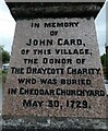
Draycott Memorial: panel two (inscription)
For the full memorial see this photo by Geograph legend Derek Harper https://www.geograph.org.uk/photo/2584594
Image: © Basher Eyre
Taken: 18 Aug 2023
0.11 miles
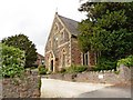
8
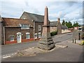
Monument, Draycott
At the foot of The Batch, and dated 1901. The stone is perhaps "Draycott Marble", a local pinkish conglomerate. Behind it is the A371.
Image: © Derek Harper
Taken: 15 Aug 2011
0.12 miles
9
Draycott: looking south-southeast from the memorial
Image: © Basher Eyre
Taken: 18 Aug 2023
0.12 miles
10
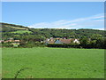
Draycott village
The Mendip Hills rise behind the village.
Image: © David Purchase
Taken: 21 Aug 2011
0.12 miles