IMAGES TAKEN NEAR TO
Westfield Lane, CHEDDAR, BS27 3TP
Introduction
This page details the photographs taken nearby to Westfield Lane, BS27 3TP by members of the Geograph project.
The Geograph project started in 2005 with the aim of publishing, organising and preserving representative images for every square kilometre of Great Britain, Ireland and the Isle of Man.

There are currently over 7.5m images from over14,400 individuals and you can help contribute to the project by visiting https://www.geograph.org.uk
Image Map
Images are licensed for reuse under creativecommons.org/licenses/by-sa/2.0
Notes
- Clicking on the map will re-center to the selected point.
- The higher the marker number, the further away the image location is from the centre of the postcode.
Image Listing (14 Images Found)
Images are licensed for reuse under creativecommons.org/licenses/by-sa/2.0
Image
Details
Distance
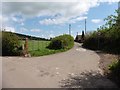
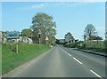
2
Draycott village
The Mendip Hills rise behind the village.
Image: © David Purchase
Taken: 21 Aug 2011
0.13 miles
3
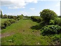
Trackbed of former Yatton to Wells railway
Image: © Roger Cornfoot
Taken: 2 May 2018
0.15 miles
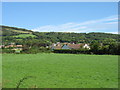
4
A Cottage in Draycott
Anyone know the name of this cottage?
Image: © Adrian and Janet Quantock
Taken: 24 Feb 2006
0.16 miles
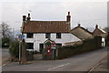
6
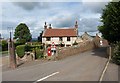
Cottage in Draycott
See Image; the name of the cottage is Old Cross, for the remains of the cross on the left, at the junction of School Lane (right, carrying the West Mendip Way) and the A371.
Image: © Derek Harper
Taken: 15 Aug 2011
0.20 miles
7
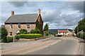
Houses in Draycott
The listed Westfield House http://www.britishlistedbuildings.co.uk/en-268110-westfield-house-rodney-stoke and The Old Cross are on either side of the A371 in Draycott. This is the route of the West Mendip Way, which forks right up School Lane.
Image: © Derek Harper
Taken: 15 Aug 2011
0.20 miles
8
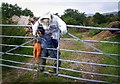
Get Orf My Laand!
I'm seeing more and more scarecrows around the place. They're making a bit of a comeback.
Image: © Des Blenkinsopp
Taken: 19 Aug 2014
0.21 miles
9
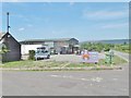
Draycott, Cider Barn
On Draycott Road, a two-roomed cider house, with outdoor seating and light meals. Inside, eccentric decoration; half a dozen ciders and one cask ale on offer.
Image: © Mike Faherty
Taken: 4 Aug 2018
0.22 miles
10
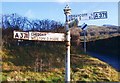
Direction Sign - Signpost on the A371 in Draycott
Pyramid finial - 3 arms; Somerset SCC pyramid by the A371, in parish of Cheddar (Sedgemoor District), in Draycott on the north side of the crossroads of the A371 Draycott Road and Latches Lane.
surveyed
Milestone Society National ID: SO_ST4751A
Image: © Milestone Society
Taken: Unknown
0.22 miles