IMAGES TAKEN NEAR TO
Parsons Pen, CHEDDAR, BS27 3RE
Introduction
This page details the photographs taken nearby to Parsons Pen, BS27 3RE by members of the Geograph project.
The Geograph project started in 2005 with the aim of publishing, organising and preserving representative images for every square kilometre of Great Britain, Ireland and the Isle of Man.

There are currently over 7.5m images from over14,400 individuals and you can help contribute to the project by visiting https://www.geograph.org.uk
Image Map
Images are licensed for reuse under creativecommons.org/licenses/by-sa/2.0
Notes
- Clicking on the map will re-center to the selected point.
- The higher the marker number, the further away the image location is from the centre of the postcode.
Image Listing (129 Images Found)
Images are licensed for reuse under creativecommons.org/licenses/by-sa/2.0
Image
Details
Distance
1
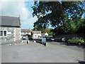
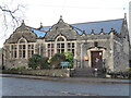
Parking for church hall, St Andrew's Church
St. Andrew's boasts a very extensive church hall with a variety of rooms of different sizes. http://www.standrewscheddar.org.uk/?page_id=148
Image: © HelenK
Taken: 10 Jul 2014
0.02 miles
2
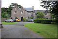
The Vicarage, Parsons Pen, Cheddar
Grade II Listed mid 19th century vicarage of 15th century or earlier origin. In the garden of the vicarage are the remains of a Roman villa, clearly seen outlined in the lawn from St. Andrew’s Tower, particularly in dry weather. Delineations of the North Western 1829 by John Rutter tells us that the "southern wing has been completely re-built, and the other parts, comprising the old hall, have been considerably repaired in the original style by the present vicar". This was probably Rev. Hervey who observed structural remains which led him to believe that one wing of the 19th century Vicarage overlies the site of an earlier barn. This idea is supported by two surveys of 1633 and 1635 which describe an extensive complex of buildings within the Vicarage plot, including a hall and porch, a parlour with a chamber over it, a kitchen with a chamber over it, a buttery also with a chamber over it, a dairy, barn, stable, stalls, orchard and garden, a courtyard on the north side of the house, a mow barton, and a backside.
Image: © Jo and Steve Turner
Taken: 16 Jun 2019
0.03 miles
4
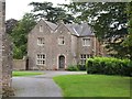
Vicarage, Cheddar
The Victorian building, described as "Muscular Gothic" http://www.britishlistedbuildings.co.uk/en-268771-the-vicarage-cheddar , is adjacent to Image
Image: © Derek Harper
Taken: 13 Aug 2011
0.04 miles
5
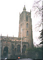
St Andrew's church, Cheddar
The 110' tower dates from c.1400AD.
Image: © Stephen Craven
Taken: 16 Feb 1994
0.04 miles
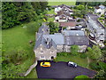
6
Cheddar-Saint Andrew's Church House
The view from Parson's Pen.
Image: © Ian Rob
Taken: 24 Sep 2013
0.04 miles
8
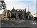
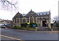
Village Hall, Cheddar
Formerly Church House, the hall is a large, school-like building opposite St Andrew's church and bears a memorial stone high on the east wall - see Image
Image: © Neil Owen
Taken: 7 Jan 2023
0.04 miles
9
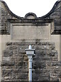
Memorial stone on the hall wall
Richard à Court Beadon was vicar of Cheddar for 47 years and his daughter funded the building of this village hall. Originally just two rooms, it was designed by E. Buckle. The stone is dated 1894 and the hall was officially opened on 18th July, 1895, in the presence of Bishop of Bath and Wells and the Dean of Wells. See Image] for a wider view.
Image: © Neil Owen
Taken: 7 Jan 2023
0.04 miles
10
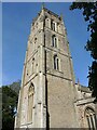
St Andrew's tower
The church was founded in the fourteenth century and the west tower added around 1423. It stands at 30m (100 ft) tall and has a peel of eight bells.
Image: © Neil Owen
Taken: 16 Sep 2024
0.05 miles