IMAGES TAKEN NEAR TO
Albion Terrace, CHEDDAR, BS27 3PW
Introduction
This page details the photographs taken nearby to Albion Terrace, BS27 3PW by members of the Geograph project.
The Geograph project started in 2005 with the aim of publishing, organising and preserving representative images for every square kilometre of Great Britain, Ireland and the Isle of Man.

There are currently over 7.5m images from over14,400 individuals and you can help contribute to the project by visiting https://www.geograph.org.uk
Image Map
Images are licensed for reuse under creativecommons.org/licenses/by-sa/2.0
Notes
- Clicking on the map will re-center to the selected point.
- The higher the marker number, the further away the image location is from the centre of the postcode.
Image Listing (142 Images Found)
Images are licensed for reuse under creativecommons.org/licenses/by-sa/2.0
Image
Details
Distance
1
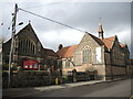
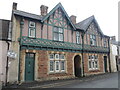
Cheddar Methodist church
The original church building is on the right of shot, with the modern version now on the left.
Image: © Neil Owen
Taken: 7 Jan 2023
0.02 miles
3
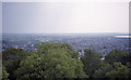
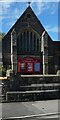
The view southwest from the observation tower
Image: © Barry Shimmon
Taken: 1 Aug 1995
0.04 miles
5
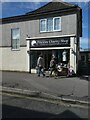
Flowers & Kickboxing
According to the signs that's the unlikely partnership in these premises along Cliff Street.
Image: © Des Blenkinsopp
Taken: 28 Aug 2014
0.07 miles
6
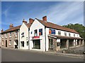
Redcliffe Street, Cheddar
Redcliffe Street in the village of Cheddar in Somerset.
Image: © Malc McDonald
Taken: 22 Aug 2020
0.07 miles
7
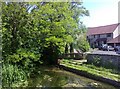
Stream with steps
A small stream viewed from a bridge on Redcliffe Street, Cheddar. It is possibly called the Bray, as the adjacent turning is called Braybridge.
Image: © mick finn
Taken: 30 May 2009
0.08 miles
8
Sign by Swiss Villa
At the top end of union Street is the old sign for the Gorge - see Image] for a closer look at the listing post.
Image: © Neil Owen
Taken: 7 Jan 2023
0.08 miles
9
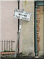
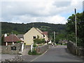
Sharp left - the Gorge
An old sign points visitors up the road towards the famous Cheddar Gorge. As it happens, there are more bends before reaching it, some of which are quite twisty. See Image] for a wider view.
Image: © Neil Owen
Taken: 7 Jan 2023
0.08 miles
10
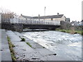
River rising
The Cheddar Yeo runs down from the Gorge and after some prolonged rainfall is now running close to the top of the footbridge on Redcliffe Street. A small set of steps allow some close contact in better weathers, close to the site of Cheddar's old mills.
Image: © Neil Owen
Taken: 7 Jan 2023
0.08 miles