IMAGES TAKEN NEAR TO
Orchard Way, CHEDDAR, BS27 3JA
Introduction
This page details the photographs taken nearby to Orchard Way, BS27 3JA by members of the Geograph project.
The Geograph project started in 2005 with the aim of publishing, organising and preserving representative images for every square kilometre of Great Britain, Ireland and the Isle of Man.

There are currently over 7.5m images from over14,400 individuals and you can help contribute to the project by visiting https://www.geograph.org.uk
Image Map
Images are licensed for reuse under creativecommons.org/licenses/by-sa/2.0
Notes
- Clicking on the map will re-center to the selected point.
- The higher the marker number, the further away the image location is from the centre of the postcode.
Image Listing (79 Images Found)
Images are licensed for reuse under creativecommons.org/licenses/by-sa/2.0
Image
Details
Distance

3
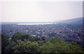
The view westwards from the observation tower
Looking towards Cheddar Reservoir.
Image: © Barry Shimmon
Taken: 1 Aug 1995
0.04 miles
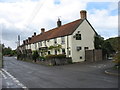
4
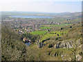
Cheddar town and reservoir
From the north rim of the gorge.
Image: © Ken Grainger
Taken: 4 Apr 2007
0.04 miles
5
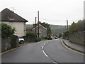
Tweentown, Cheddar
A strange name for the B3135; looking towards the village centre.
Image: © M J Richardson
Taken: 31 Oct 2013
0.06 miles
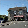
7
The Gardeners Arms, Silver Street, Cheddar
Image: © David Purchase
Taken: 7 Oct 2011
0.12 miles
8
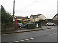
Lower North Street, Cheddar
Telephone box at the junction of Lower North Streret and the B3135.
Image: © M J Richardson
Taken: 31 Oct 2013
0.13 miles
9
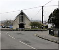
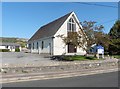
Our Lady Queen of Apostles Church, Cheddar
Image: © PAUL FARMER
Taken: 18 Feb 2017
0.13 miles