IMAGES TAKEN NEAR TO
Banwell Road, AXBRIDGE, BS26 2YA
Introduction
This page details the photographs taken nearby to Banwell Road, BS26 2YA by members of the Geograph project.
The Geograph project started in 2005 with the aim of publishing, organising and preserving representative images for every square kilometre of Great Britain, Ireland and the Isle of Man.

There are currently over 7.5m images from over14,400 individuals and you can help contribute to the project by visiting https://www.geograph.org.uk
Image Map (Loading...)


Getting Data...Please wait
Leaflet Map data © OpenStreetMap
Images are licensed for reuse under creativecommons.org/licenses/by-sa/2.0
Notes
- Clicking on the map will re-center to the selected point.
- The higher the marker number, the further away the image location is from the centre of the postcode.
Image Listing (17 Images Found)
Images are licensed for reuse under creativecommons.org/licenses/by-sa/2.0
Image
Details
Distance
1
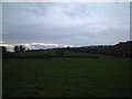
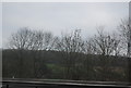
Field
View of fields from Yarberry Farm.
Image: © Adrian and Janet Quantock
Taken: 5 Nov 2005
0.08 miles
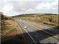
2
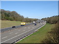
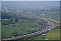
M5 near Christon, looking towards Bristol
Image: © Ruth Sharville
Taken: 8 Apr 2010
0.14 miles
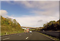
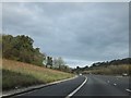
3
The M5 near Christon
Crook Peak is a prominent feature ahead for southbound traffic.
Image: © Bill Boaden
Taken: 19 May 2018
0.15 miles
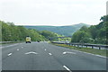
6
M5 cutting east of Christon
The M5 passes through a shallow cutting as it climbs out of the Lox Yeo valley
Image: © David Smith
Taken: 5 Nov 2011
0.15 miles
7
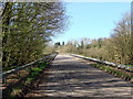
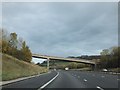
Road to Christon about to cross the M5
Image: © Ruth Sharville
Taken: 8 Apr 2010
0.16 miles
8
Sedgemoor : Crook Peak Scenery
Looking down towards the M5 Motorway from Crook Peak.
Image: © Lewis Clarke
Taken: 9 Apr 2017
0.16 miles
9
Bridge between Christon and Yarborough over M5
Image: © David Smith
Taken: 5 Nov 2011
0.17 miles