IMAGES TAKEN NEAR TO
White House Lane, AXBRIDGE, BS26 2UU
Introduction
This page details the photographs taken nearby to White House Lane, BS26 2UU by members of the Geograph project.
The Geograph project started in 2005 with the aim of publishing, organising and preserving representative images for every square kilometre of Great Britain, Ireland and the Isle of Man.

There are currently over 7.5m images from over14,400 individuals and you can help contribute to the project by visiting https://www.geograph.org.uk
Image Map
Images are licensed for reuse under creativecommons.org/licenses/by-sa/2.0
Notes
- Clicking on the map will re-center to the selected point.
- The higher the marker number, the further away the image location is from the centre of the postcode.
Image Listing (15 Images Found)
Images are licensed for reuse under creativecommons.org/licenses/by-sa/2.0
Image
Details
Distance
1
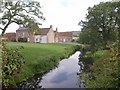
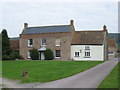
White House Farm and Mark Yeo
The river flows (away from the camera) past Image, which is a late C18 farmhouse http://www.britishlistedbuildings.co.uk/en-434386-white-house-farmhouse-east-brent .
Image: © Derek Harper
Taken: 23 Sep 2010
0.01 miles
4
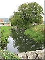
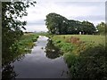
Mark Yeo River
This river runs adjacent to White House Farm, the flood control sluice can just be seen beyond the tree.
Image: © Dr Duncan Pepper
Taken: 6 Oct 2007
0.02 miles
5
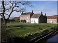
White House Farm
An attractive Georgian farm house adjacent to the Mark Yeo river in the Somerset Levels.
Image: © Dr Duncan Pepper
Taken: 6 Oct 2007
0.03 miles
6
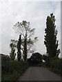
Poplars at White House Farm
This mature stand of poplars in White House Lane in the Somerset Levels is a sure sign of a high water table.
Image: © Dr Duncan Pepper
Taken: 6 Oct 2007
0.04 miles
7
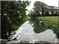
Mark Yeo River
This river runs past White House Farm and drains into the River Axe nearby. Being in the Somerset Levels, it has sluice gates to control flooding.
Image: © Dr Duncan Pepper
Taken: 6 Oct 2007
0.08 miles
8
Mark Yeo
Looking upstream from the other side of the bridge from which Image was taken; a very similar view to Image
Image: © Derek Harper
Taken: 23 Sep 2010
0.08 miles
9
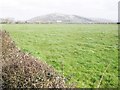
Field to the east of White House Lane
Crook Peak can be seen in the distance.
Image: © Roger Cornfoot
Taken: 19 Mar 2014
0.16 miles
10
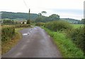
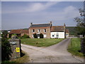
White House Lane
Puddles beside a generously sized passing place as the lane approaches White House Farm, which is in Image
Image: © Derek Harper
Taken: 23 Sep 2010
0.18 miles